Eastern Express Connector

The Eastern Express Connector is DIGITAL-ONLY. No paper maps are produced for this route. This route is available digitally.
A speedier version of the classic TransAmerica.
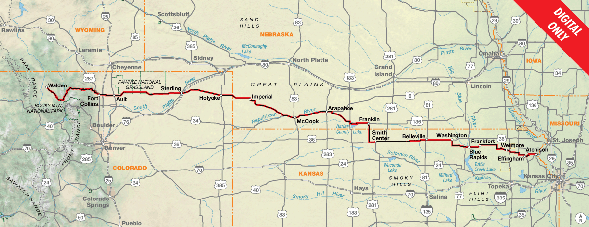
The Eastern Express Connector links the TransAmerica Trail in Walden, Colorado to the Chicago to New York City Bicycle Route in Indianapolis, Indiana. Originally created by veteran Adventure Cycling tour leader Frank Moritz, this variation of the classic TransAmerica Trail was designed to be a quicker (and easier) coast-to-coast experience for the time-constrained cyclist. Combined with the Chicago to New York City Route in the east, this route bypasses the most strenuous climbing in the Southern Rockies, Ozarks, and Appalachians, with the added benefit of avoiding the troublesome dog regions on the existing TransAmerica Trail.

Heading eastbound from Walden, the Eastern Express Connector crosses the Southern Rocky Mountains only once in Colorado at Cameron Pass, compared to the three high elevation passes on the traditional route. The route then descends the scenic Poudre River canyon into the bicycle-friendly college town of Fort Collins, the last significant population until you reach the St. Louis metro area in Missouri. Things start to dry out as you get into the eastern part of Colorado and cross into the southwestern corner of Nebraska. Carrying extra water is a good idea here – this is hot, barren country and services are limited. You might even have to do some early morning and early evening riding to escape the heat of the midday sun. Thankfully, many of the small towns along the way have public swimming pools, so pack your swimsuit!
The route through Kansas continues to be rural in nature, with not a single town’s population over 2,000 until Atchison. Near Lebanon, you’ll have the unique opportunity to visit the Geographic Center of the Contiguous U.S., as determined by a 1918 survey.
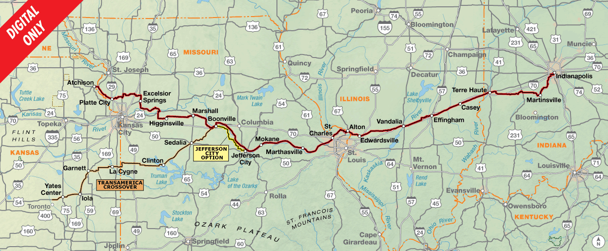
A highlight of the Connector is the historic Katy Trail, the country’s longest recreational rail trail. Now a state park, the crushed-limestone trail is built on the former corridor of the Missouri-Kansas-Texas Railroad and winds alongside the mighty Missouri River. The trail skirts the northern edge of the Ozark Mountains, avoiding the notorious climbing further south on the TransAmerica Trail, but the low-lying trail floods often due to its proximity to the river. Check for trail conditions and be prepared for detours if necessary. The Jefferson City Option can be used if the western portion of the Katy Trail is flooded.
In Boonville, Missouri, the “TransAmerica Crossover”, an alternate included with the Eastern Express Connector Route, provides a mid-way connection to the traditional TransAmerica Trail. Using a combination of the Katy and Prairie Spirit Trails, it links up with Section 8 of the TransAm just north of Toronto, Kansas. For cyclists who also plan to ride the Western Express, this Crossover creates a more streamlined route across Middle America.
After crossing the Mississippi River on the bike-friendly Clark Bridge, the Eastern Express Connector beelines across Illinois to the college town of Terre Haute, Indiana, a nice spot for a layover if you have the time. Don’t miss the roadside attraction town of Casey, Illinois, home to the world’s largest rocking chair, mailbox, pitchfork, and more.
The Connector finally terminates in Indianapolis, the state capital and largest city in Indiana. From here, ride onto the Chicago to New York City Bicycle Route to continue east on your “express” cross-country journey. In Pittsburgh, split off onto the Philadelphia Alternate which uses a combination of the historic Great Allegheny Passage (GAP) rail-trail and the C&O Canal Towpath trail to gently slice through the rugged Appalachian Mountains, in great contrast to the severe rollercoaster climbs you would instead encounter in eastern Kentucky and western Virginia on the classic TransAmerica Trail.
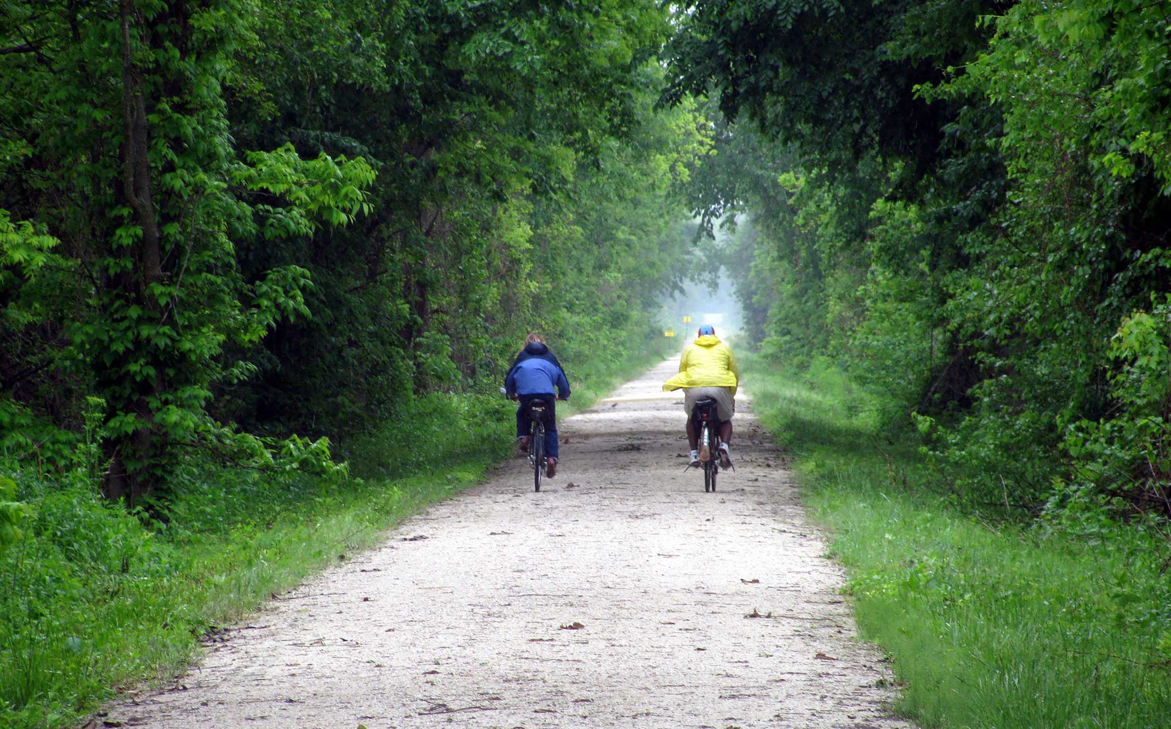
CC Image courtesy of joneser005 on Flickr
Western Colorado is high elevation, and you may notice shortness of breath if not accustomed to the altitude. The climb up to Cameron Pass (elev. 10,276 ft.) is long, but gradual and gently graded. The descent into Fort Collins is, of course, a blast with almost 60 miles of continuous downhill.
The ride across the Great Plains is gloriously flat, although brutal wind may take away any enjoyment gained from the lack of topography.
There are some gentle rollers in eastern Kansas, but the hills really begin in earnest in western Missouri. Climbing is different here than in the Rockies; the grades are short, steep, and numerous.
The Katy Trail provides relief from the constant Missouri hills. The trail is built atop an old railroad bed along the Missouri River, and is almost completely flat.
The terrain through Illinois and Indiana is defined by mellow ups and downs typical of the Midwest, with only a handful of notable climbs.
| Eastern Express Connector - Main Route | ||||
|---|---|---|---|---|
| Section | Distance | Elevation | Total Climb | Avg. Climb/mile |
| Total | 1337.4 miles | Minimum: 400 ft.Maximum:10,275 ft. | 26,960 ft. east bound34,485 ft. west bound | 20 ft. per mi. east bound26 ft. per mi. west bound |
| 1 | 700.1 miles | Minimum: 820 ft.Maximum:10,275 ft. | 8,220 ft. east bound15505 ft. west bound | 12 ft. per mi. east bound22 ft. per mi. west bound |
| 2 | 637.3 miles | Minimum: 400 ft.Maximum:1160 ft. | 18,740 ft. east bound18,980 ft. west bound | 29 ft. per mi. east bound30 ft. per mi. west bound |
| Eastern Express Connector Alternates | ||||
|---|---|---|---|---|
| Name | Section | Distance | Total Climb | Avg. Climb/mile |
| Jefferson City Option | 2 | 54.5 miles | 3,275 ft. east bound3,350 ft. west bound | 60 ft. per mi. east bound61 ft. per mi. west bound |
| TransAmerica Crossover | 2 | 227.2 miles | 6,675 ft. east bound6,960 ft. west bound | 29 ft. per mi. east bound31 ft. per mi. west bound |
This route is primarily intended as a connector between the TransAmerica Trail and Chicago to New York City routes, collectively acting as a shortcut to the east coast by avoiding the Southern Rockies, Ozarks, and Appalachians. If you also intend on riding the Western Express Route, use the TransAmerica Crossover for a more direct course to/from Pueblo, Colorado.
With the exception of Fort Collins, Section 1 of this route is rural and dotted with small towns at 20–40-mile intervals, although services in some of these towns are limited or non-existent. There are no bike shops on route between Fort Collins and Atchison, and the bike shop in Atchison is limited. Services become more frequent on Section 2.
The Katy Trail in Missouri commonly floods during high-water events. Even if the trail is not currently underwater, damage from a recent flood may force some sections to remain closed. The Jefferson City Option can be used if any portion of the Katy Trail from Boonville to Jefferson City is closed. If the eastern portion of the Katy Trail is flooded, you’ll have to get creative with a detour of your own.
Some campgrounds will charge a cyclist traveling alone less if they have hiker/biker sites, but often they will charge the price of a regular tent site, and that can easily be $10-$20/night. If you’re friendly and ask around, you can often get yourself invited to camp in a yard. In national forests you are allowed to camp anywhere on national forest land as long as you “pack it in, pack it out.” Many city parks are free to camp in.
Missouri State Parks have a no-turn-away policy which can be found at advcy.link/noturnaway.
This route can be ridden from May through September. Note that snow can occur at any time in the Rocky Mountains, and Cameron Pass in Colorado is over 10,000 feet in elevation. Although the prevailing weather patterns are overall from west to east, local wind patterns are more dependent on the passing pressure systems and local terrain, so you can expect your fair share of tailwinds, crosswinds, and headwinds regardless of which direction you ride the route.
You may also wish to sign up with Warmshowers, a reciprocal hospitality site for bicycle travelers, for other overnight options.
Eastern Express Connector Highlights
- Cameron Pass and Poudre River Canyon, Section 1
- Fort Collins, Section 1
- Pawnee National Grasslands, Section 1
- Enders Reservoir State Recreation Area, Section 1
- Home on the Range Cabin, Section 1
- Geographic center of the US, Section 1
- Amelia Earhart Birthplace Museum, Section 1 & 2
- Lewis & Clark State Park, Section 2
- Weston Bend State Park, Section 2
- Watkins Mill State Park, Section 2
- Arrow Rock Historic District, Section 2
- Katy Trail, Section 2
- Prairie Spirit Trail, Section 2, TransAmerica Crossover
- St. Charles Historic Main Street, Section 2
- Nickel Plate Trail, Section 2
- World’s Largest Items in Casey, IL, Section 2
- National Road Heritage Trail (Terre Haute segment), Section 2
- Lieber State Recreation Area, Section 2
More Route Resources
- U.S. Bicycle Route System
- How to Travel with your Bike on Amtrak
- Fort Collins Bike Map (Colorado)
- Colorado Traffic Volume Map
- Kansas Bicycle Map
- Katy Trail Potential Flood Locations (Missouri)
- Bike Katy Trail (Missouri)
- Katy Trail State Park (Missouri)
- No-Turn-Away Bike Camping Policies (Missouri)
- Missouri Traffic Volume Map
- Missouri Highway Closures and Construction Map
- Prairie Spirit Trail (TransAmerica Crossover, Kansas)
- Madison Country Transit Trails (Illinois)
- US Bicycle Route 235 (Indiana)
- National Road Heritage Trail (Indiana)
- Indianapolis Bike Map (Indiana)
- Eagle Creek Trail (Indiana)
- White River Wapahani Trail (Indiana)
- Warmshowers
- How to Deal with Dog Encounters
- Connect and share photos with other riders on Instagram: #acaEastExpConn
Updates to Recently Released Maps
If you are planning a bike tour, be sure to get the most recent map updates and corrections for your route by selecting the route, and the appropriate section(s), from the drop-down menu below.
Over time maps become less useful because things change. Every year Adventure Cycling’s Routes and Mapping Department create map updates and corrections for every map in the Adventure Cycling Route Network, which now totals 52,047 miles. With the help of touring cyclists like you, we receive updates on routing, services, camping, and contact information. Until we can reprint the map with the new information, we verify the suggested changes and publish corrections and updates here on our website.
PLEASE NOTE: Covid has been particularly hard on the small businesses along our routes. While we do our best to keep the maps and these online updates current, you may encounter more closed businesses and longer stretches with limited or no services.
Refer to these updates for the most current information we have and submit reports of changes to the Route Feedback Form for the cyclists coming after you.
NOTE: Map updates and corrections only pertain to long term changes and updates. For short term road closures, please see the Adventure Cycling’s Routes Temporary Road Closures discussion in our Forums.

