Pacific Coast

Pacific Coast Vancouver, BC to Imperial Beach, CA 5 Map Set GPX Data | Overview | Buy | Mobile App
1. Vancouver, BC to Astoria, OR Detail
2. Astoria, OR to Crescent City, CA Detail
3. Crescent City, CA to San Francisco, CA Detail
4. San Francisco, CA to Santa Barbara, CA Detail
5. Santa Barbara, CA to Imperial Beach, CA Detail

Big trees, big waves, beautiful beaches.

Along the Pacific Coast Route, you’ll get to see marine wildlife such as sea lions, and as you pass you can hear them barking. Take the time to watch as one by one they dive off their rocks in search of their daily meal of fish from the ocean. During the peak tourist season, there is heavy recreational vehicle traffic along U.S. Highway 101 and State Highway 1 along the coast, so cyclists must ride cautiously and defensively.

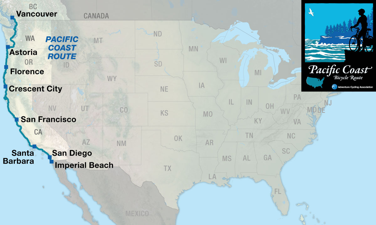
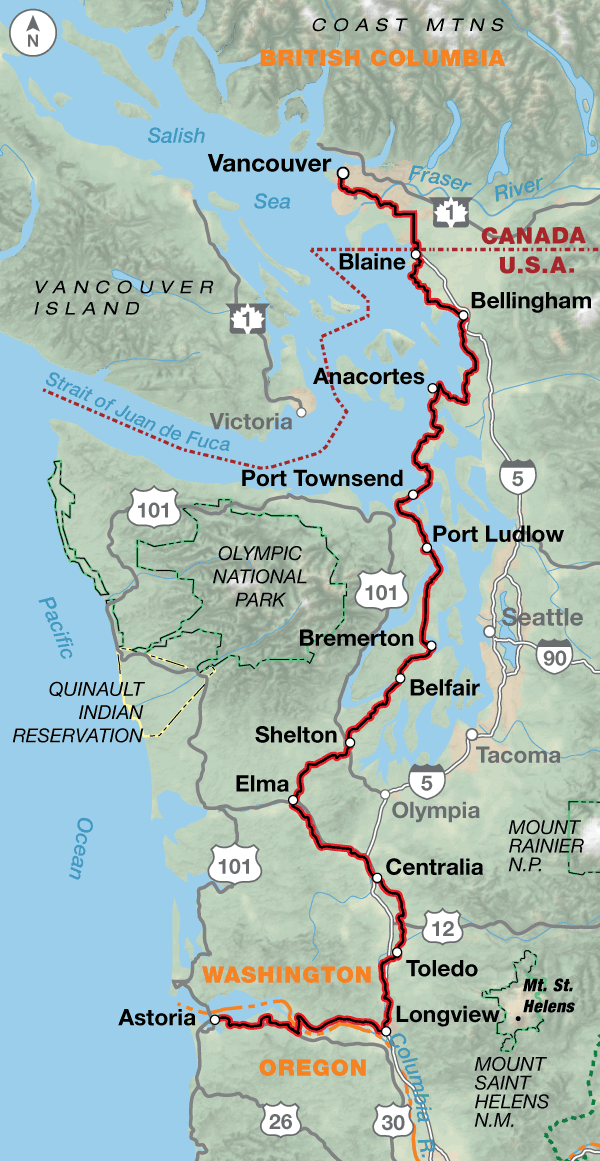
The route begins in Vancouver, British Columbia and heads south through the suburbs of this large city. Farmlands appear before crossing the border at Blaine into the United States, and you’ll continue through more rural countryside in Washington. After crossing Deception Pass, the route is on Whidbey Island, where there is a large U.S. Naval Reservation, and the loud noise of test jets flying overhead can be heard. There’s a ferry ride over to Port Townsend, which is back on the mainland. The route then winds southward through a series of small towns on the eastern side of the Olympic Peninsula. In Bremerton, if you’re interested, you can take a ferry to downtown Seattle and its attractions. You’ll then head into logging country and see forest plantations in various stages of development: recently clear-cut, newly planted, middle-aged, or ready to be harvested. At Castle Rock, a five-mile side trip leads to the Mount St. Helens Visitor Center, which tells the tale of the volcano’s eruption in 1980.

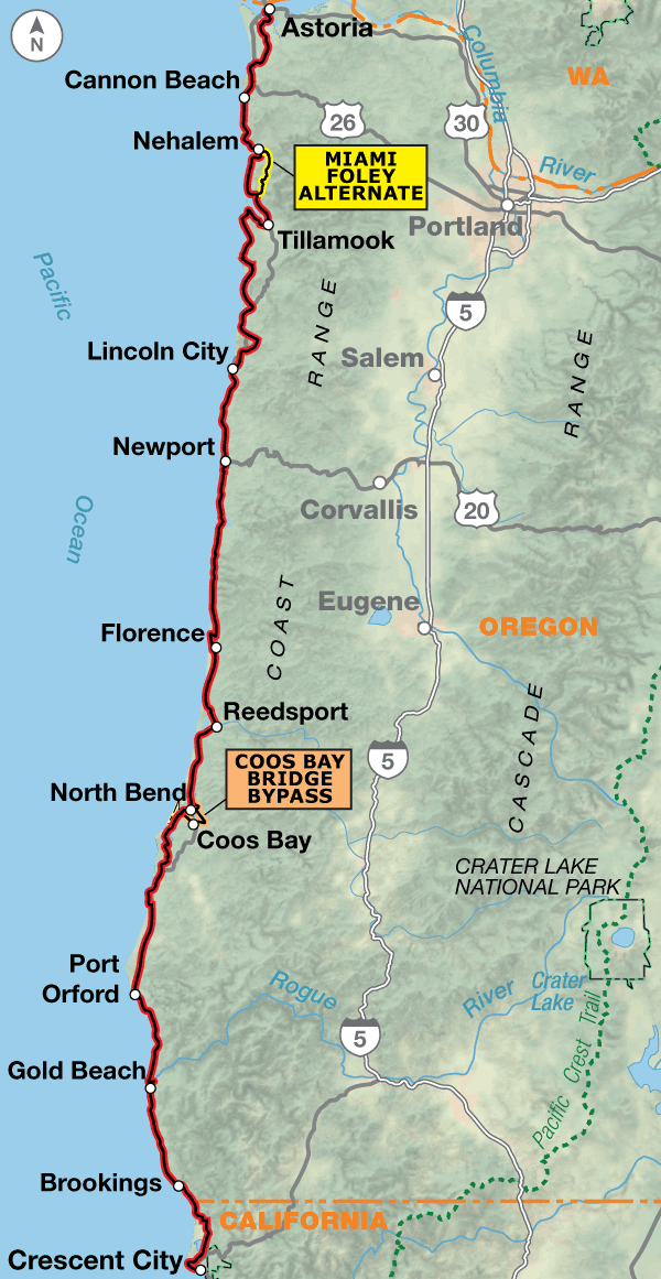
A short ferry ride crosses the Columbia River into Oregon. Leaving Astoria, you’ll begin a magnificent ride down the coast. The route stays along the shoreline and headlands, passing mile after mile of spectacular scenery including lighthouses, craggy coastal pines, and rock formations in the water. Innumerable parks dot the coast and invite one to stop, and take hikes down to the water for tide pool viewing. Small towns are abundant and cater to the tourists who invade the coast from spring to fall.

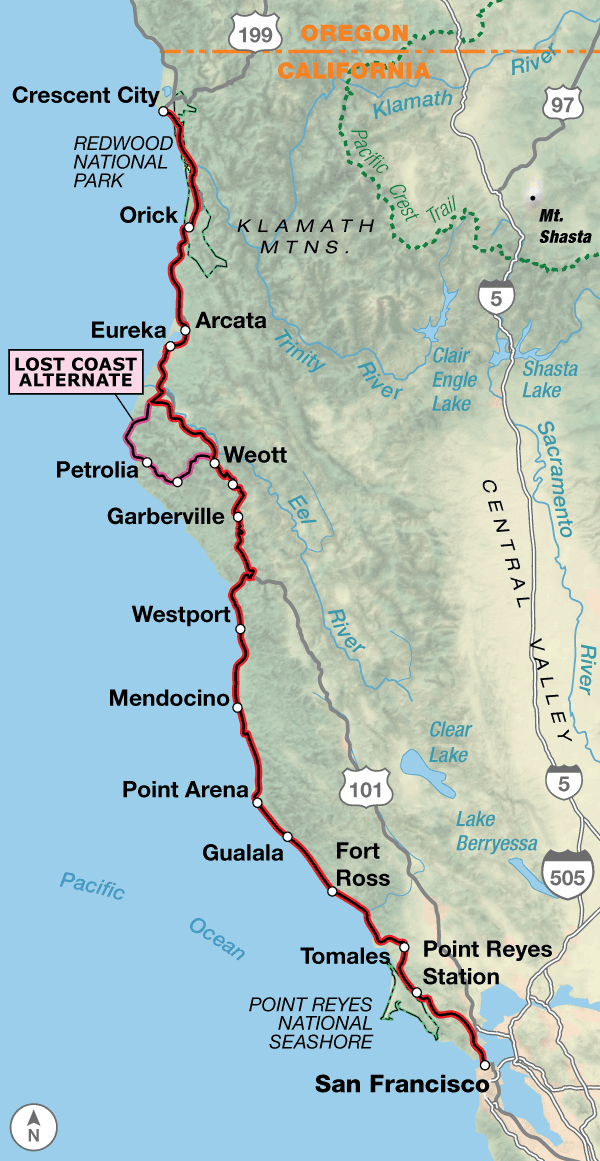
The California coast is tremendously diverse. You’ll encounter massive redwoods, breathtaking coastline vistas, acres and acres of vegetable farms, fruit orchards, and many busy urban areas.

The curvy, winding roads along the coast are shared with cars, recreational vehicles, farm trucks, and logging trucks, so extra caution is needed by cyclists. There are bike paths in some of the large cities the route goes through, and you’ll need all your defensive urban cycling skills to contend with the heavy traffic. But this is California, land of sun and fun (especially along the southern portion of the route). Take advantage and go jump into the Pacific on a whim or watch a beautiful sunset.

Soon after passing through Crescent City, you will be biking through awe-inspiring redwood country on roads shaded by trees reaching high into the sky. A herd of elk live near Orick and are usually easy to spot. The redwoods are a big tourist area, so you’ll have the opportunity to bike through trees that most people drive their cars through. After leaving the redwoods, you’ll enjoy scenic riding along the Pacific Ocean, where the route climbs and descends along the coastal headlands.

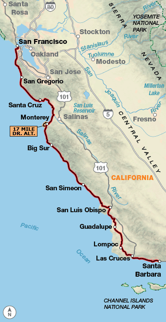
Biking over the Golden Gate Bridge into San Francisco is a real treat, and the route stays on the western edge of the city. Heading southward along the coast, there are numerous state beaches. If you’re at the Año Nuevo State Reserve during the elephant seal mating season in January, viewing the seals is not to be missed. North of Monterey, acres of farms begin to appear in the Salinas Valley, a prime agricultural area known as the “Salad Bowl of the World.”

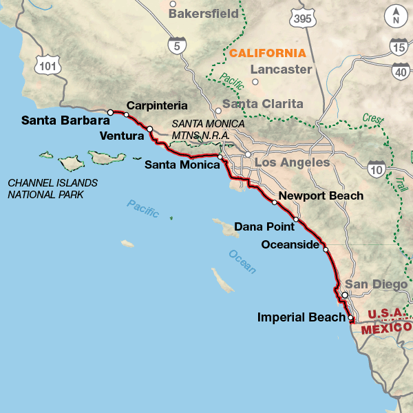
After leaving Carmel, the ride south on the Pacific Coast Highway along the Big Sur Coast is the most spectacular portion of the route for many cyclists. This winding, scenic road high above the ocean has been seen many times in television shows, commercials, and movies. Leaving the Santa Lucia Mountains and the coast, it is evident that you’ve reached “southern” California. You’ll encounter many fertile farms and areas with various degrees of development. Santa Barbara is an easy town to cycle through. When you reach Malibu, you’ll find tremendous congestion and view hundreds of trophy homes built into the hillsides or along the beaches. This is the northern end of the Los Angeles megalopolis.

Beginning in Santa Monica, the route uses some beautiful bike paths that go right through the middle of the sandy beaches, and then you’ll ride through residential and industrial areas before rejoining the Pacific Coast Highway south of the city. All the way to San Diego, there will be a mix of urban cycling through towns, bike paths, highways, and shore roads. Through San Diego and its suburbs, the route follows residential streets and bike paths to the Coronado Pedestrian-Bicycle Ferry, which takes you to Coronado and a bike path along Silver Strand State Beach, then to the route’s end at Border Field State Park next to the Mexican border.
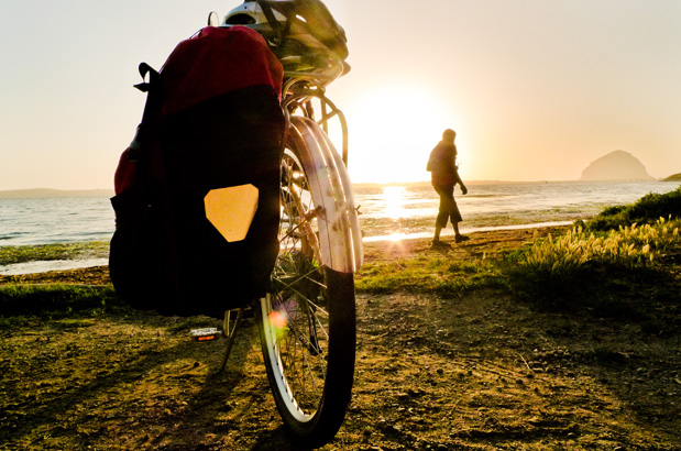
Photo by Russ Roca

The route’s terrain in Canada and Washington is flat to rolling hills, with a few climbs. Biking along the Oregon coast means hills, and some of them are steep, but it also means that your spectacular views will be well-earned. Don’t forget that your uphills on one side of a coastal headland mean a downhill on the other side.

Northern California is generally hilly, with lots of ups and downs following the coastline. There is a large climb/descent between Leggett and the coastal highway on section 3. The route remains hilly until Santa Barbara. Some sections in the southern part of the route are rolling to flat, especially along the various cities’ bike paths along the beaches.

Pacific Coast - Main Route
Section Distance Elevation Total Climb Avg. Climb/mile
Total 1,862.6 miles Minimum: 0 ft.
Maximum:1,910 ft.
106,520 ft. south bound
106,045 ft. north bound
57 ft. per mi. south bound
57 ft. per mi. north bound
1 413.5 miles Minimum: 0 ft.
Maximum:660 ft.
18,715 ft. south bound
18,950 ft. north bound
45 ft. per mi. south bound
46 ft. per mi. north bound
2 407.7 miles Minimum: 0 ft.
Maximum:840 ft.
22,840 ft. south bound
22,620 ft. north bound
56 ft. per mi. south bound
55 ft. per mi. north bound
3 407.8 miles Minimum: 0 ft.
Maximum:1,910 ft.
30,545 ft. south bound
29,830 ft. north bound
75 ft. per mi. south bound
73 ft. per mi. north bound
4 383.1 miles Minimum: 0 ft.
Maximum:1,135 ft.
26,935 ft. south bound
27,105 ft. north bound
70 ft. per mi. south bound
71 ft. per mi. north bound
5 250.5 miles Minimum: 0 ft.
Maximum:445 ft.
7,482 ft. south bound
7,540 ft. north bound
30 ft. per mi. south bound
30 ft. per mi. north bound
Pacific Coast Alternates
Name Section Distance Total Climb Avg. Climb/mi
Seattle Ferry Spur 1 1.4 miles 150 ft. east bound
175 ft. west bound
107 ft. per mi. east bound
125 ft. per mi. west bound
Coos Bay Bridge Bypass 2 16.9 miles 960 ft. south bound
1,015 ft. north bound
57 ft. per mi. south bound
60 ft. per mi. north bound
Miami Foley Alternate 2 14 miles 470 ft. south bound
450 ft. north bound
34 ft. per mi. south bound
32 ft. per mi. north bound
Lost Coast Alternate 3 65.5 miles 8,190 ft. south bound
8,075 ft. north bound
125 ft. per mi. south bound
123 ft. per mi. north bound
17-Mile Drive Alternate 4 11.6 miles 1,105 ft. south bound
565 ft. north bound
76 ft. per mi. south bound
39 ft. per mi. north bound

This route can be ridden at any time of the year, but spring and autumn are optimal periods to avoid the heavy tourist traffic in the summer. And be forewarned: winter rains can cause flooding and mud slides and may close roads, especially along the northern California coast. Dense fog can also be a problem during any season. Washington and Oregon normally have dry sunny weather in August and September while the spring season is usually rainy. Due to changing local conditions, it is difficult to predict any major wind patterns, but during summer, strong winds will prevail from north to south.

There are plenty of services along the route. The Oregon coast draws a large amount of tourists, so it has the facilities to cater to them. For those who are camping, there are many state park campgrounds near the beaches with hiker/biker sites.

In California, there is a stretch between Half Moon Bay and Davenport south of San Francisco that doesn’t have much to offer, so plan ahead with extra drinks and snacks. The northern and southern coasts are high-profile tourist areas, so facilities are numerous, but be prepared for higher prices. For those who like to camp, there are many appealing campgrounds at state parks near the beaches, perfect for watching dramatic sunsets. The 60 miles south of Big Sur have very limited services.

Some campgrounds will charge a cyclist traveling alone less if they have hiker/biker sites, but often they will charge the price of a regular tent or RV site, and that can easily be $20-$50/night (higher in tourist areas). The maps list churches that have opened their doors to cyclists, but they aren’t all that closely spaced. If you’re friendly and ask around, you can often get yourself invited to camp in a yard. Our routes sometimes go through national forests (moreso in the west) and you are allowed to camp anywhere on national forest land as long as you “pack it in, pack it out.”

You may also wish to sign up with Warmshowers, a reciprocal hospitality site for bicycle travelers, for other overnight options.

Public Transit Option to the US-Mexico Border at San Ysidro
You can ride on the mapped route to the Broadway Ferry Pier on the San Diego waterfront, and then ride off route 2 blocks east on Broadway to the America Plaza light rail station, where you will get on the southbound Blue Line light-rail train (although it’s referred to locally as a “trolley”).

You may take your bike aboard the San Diego Trolley at any time, even during rush hour — but there are limits. During rush hours (6-9 AM and 3-6 PM on weekdays) only one bicycle is allowed on each trolley car. At other times, two bicycles are allowed on each trolley car. Buy a regular trolley ticket or pass.

From downtown San Diego, a trip to the Mexican border will take about 45 minutes on the Imperial Way blue line. To get to the San Ysidro border station, you will need to get on the blue line at any station going south toward San Ysidro. You will take the line all the way to the end and get off at San Ysidro.

Route Highlights

Pacific Coast Highlights

  • Vancouver, British Columbia, Section 1
  • Deception Pass State Park, Section 1
  • Mount St. Helens Visitor Center, Section 1
  • Tillamook Cheese Factory, Section 2
  • Oregon Dunes National Recreation Area, Section 2
  • Samuel H. Boardman State Scenic Corridor, Section 2
  • Redwood National Park, Section 3
  • The Lost Coast, Lost Coast Alternate, Section 3
  • Humboldt Redwoods State Park, Section 3
  • Point Reyes National Seashore, Section 3
  • Golden Gate National Recreation Area, Section 3
  • San Francisco, California, Section 4
  • Golden Gate Park, Section 4
  • Monterey, California, Section 4
  • Big Sur Coast, Section 4
  • California Sea Otter Game Refuge, Section 4
  • Santa Barbara, California, Section 4
  • Los Angeles, California, Section 5
  • San Diego, California, Section 5

More Route Resources


RIDING CONDITIONS

The route through metropolitan Vancouver traverses quiet neighborhoods, commercial and busy city streets, and suburbia. It uses a combination of low and highly trafficked streets, bridge walkways, and separate bike paths. Ride defensively; traffic will be moderate to heavy almost all the way to the border. You can call 3-1-1 or 604-873-7000, or go to advcy.link/cityvanmap to download or purchase the “City of Vancouver Cycling Map and Guide.” Another useful cycling map of the Vancouver area can be found here: advcy.link/metrovanmap.

Washington’s northwest coast and its islands are a tourist destination so expect heavier summer traffic, especially on the U.S. and state highways.

In Blaine, Washington, the route follows U.S. Bicycle Route (USBR) 97 along the coastal plain south to Bellingham, which has plane, train, and bus service. On SR 548 traffic is generally light. South of Birch Bay, the route enters leased oil refinery lands with gated roads that are closed to vehicles yet remain open for cyclists. USBRs 87 and 95 briefly join the route in Bellingham, and USBR 10 runs concurrent with it near Anacortes. Be aware that signs can be damaged, stolen, or otherwise missing so you can never rely totally on following signs. For more information see advcy.link/wausbr.

In Bellingham, the route takes advantage of the multi-use separated South Bay Trail, advcy.link/sobaytrl, and the Interurban Trail, advcy.link/interurbantrl, with surfaces varying from pavement to crushed limestone. The city has moderate traffic. Leaving it, Chuckanut Dr./SR 11 has lots of weekend traffic, and shoulders on a portion of it. The route uses the Interurban Trail into and through Larrabee State Park. Sections of Chuckanut Dr./SR 11 in and south of the park are rolling and very scenic, but narrow with short sight distances, and minimal to no shoulders, so use extra caution and ride defensively.

From Anacortes, the Washington State Ferries travel to the San Juan Islands and to Sidney, British Columbia. In Washington call 888-808-7977, or outside the state 206-464-6400 for information. A ferry also runs from Bremerton to Seattle. For schedules go to advcy.link/WAstateferries. Our Washington Parks Route, Section 1 map includes routing on three of the San Juan Islands.

South of Anacortes, our routing avoids SR 20 where possible but you’ll still ride on sections of it. The Deception Pass bridge is narrow and can have heavy traffic. Whidbey Island has some rolling to hilly terrain. There are several narrow two-lane sections and congested areas near the island’s towns; traffic is generally light away from SR 20.

Leaving Port Townsend, the route uses the Larry Scott Trail, advcy.link/lscotttrl, then it’s onto rolling to hilly roads with moderate traffic. The two-lane, 1.5-mile Hood Canal Bridge has 8-foot shoulders and is subject to crosswinds. Ride to the far right to avoid several sections of the bridge deck grating.

Traffic can be heavy on the bridge and on the 3.2-mile section of SR 3 immediately south of the bridge. The route through Silverdale and Bremerton is often on nondivided four-lane roads with high levels of traffic. It follows Kitsap Way/ SR 310 into Bremerton to avoid climbing the steep hills west of town. A 1.5-mile spur is shown to reach the Bremerton ferry terminal if you want to catch a ride to Seattle. Prepare to ride defensively on the 2.3-mile stretch of highly trafficked SR 3 leaving Bremerton, but be reassured that this stretch is short and shoulders are wide.

Continuing south, roads are rural with moderate hills around Shelton and Elma. The route avoids highways as much as possible, and stays on lesser-trafficked county roads. Traffic increases on Old Highway 99 north of Centralia.

Castle Rock and Longview both have short sections of bike paths to avoid the city traffic. SR 4 carries heavy recreational traffic to and from the coast. The highway has intermittent shoulders so ride defensively. The Wahkiakum County ferry crosses the Columbia River. For a schedule see advcy.link/wahcoferry.

In Oregon, you’ll ride west on U.S. 30, which carries moderate traffic and has wide shoulders most of the way into Astoria. Routing onto several side roads give respite from the traffic. In Astoria, the Astoria Riverwalk intermittently consists of planks running in the direction of travel. Gaps between the planks can make cycling dangerous for bikes with tires narrower than 40c.

All known Amtrak stations are listed on this map but not all stations provide bicycle service. Check if bicycle service is provided at both the starting and ending stations on your trip using the spreadsheet and other trip planning resources at advcy.link/amtrak.

CLIMATE

Washington’s climate is mild and climatic elements combine to produce a predominantly marine-type climate west of the Cascade Mountains. Summers are cool and comparatively dry and winters are mild, wet and cloudy. The wet season begins in October, reaches a peak in winter, then gradually decreases in the spring.

Updated: Jun 24, 2021


RIDING CONDITIONS

U.S. Bicycle Route (USBR) 90 has been designated in Arizona. Portions of our route run concurrent with it. For more information and maps see advcy.link/azusbr.

Plan for urban cycling conditions and moderate to heavy traffic from Tempe to the turn north toward Usery Pass. Expect moderate traffic on the Bush Highway with good shoulders to the junction with Beeline Highway/SR 87. After turning onto SR 87, there is a 5-mile section of narrow road with no shoulder.

Some cyclists may choose a shorter route to Globe, AZ via US 60. This route is 61 miles shorter than the main route. On this optional route, expect variable shoulder widths and rumble strips which occasionally force you into traffic lanes which can carry heavy commercial and recreational traffic. Also on this optional route, ride very cautiously/defensively through the Queen Creek Tunnel east of Superior and on U.S. 60 into Globe. You may wish to walk your bike on the narrow sidewalk through the tunnel. The highway is narrow, traffic increases through the towns, and trucks going to the large mine west of Globe travel on the weekdays. Another option is SR 88 from Apache Junction to Roosevelt Lake via Tortilla Flat. This route is 37 miles shorter than the main route. Expect minimal services and a narrow, winding road without shoulders, including 20 miles of hard packed dirt.

U.S. 70’s shoulder between Globe and Safford is in bad condition so be careful. Services are minimal in eastern Arizona. In Duncan, replenish your stock of food and water. Services are limited for the next 70.7 miles to Silver City. A 2-mile off route ride to Lordsburg is an option for full services.

Once you reach Silver City you have a choice. The main route goes through rolling terrain; en route you’ll pass the Santa Rita Open Pit Copper Mine. The town of Santa Clara has been renamed Central, but you’ll still see the old name on street signs. In comparison, the Gila Cliff Dwellings Alternate is 68.5 miles longer. The alternate goes through historic Pinos Altos and climbs and descends through thick pine forests before reaching the Gila River drainage. This very scenic road is narrow and winding and caution is urged, especially on the descents. After leaving the Gila Cliff Dwellings National Monument, you’ll ride through forests and meadows, and begin another gradual ascent to the Continental Divide.

SR 152 is winding and steep with intermittent shoulders over Emory Pass, the highest point on the Southern Tier. In the next 33.8 miles you’ll drop 3,800 feet to the Caballo Reservoir.

From here to El Paso the route parallels the Rio Grande and I-25 including nearly 8 miles on a paved bike path to the outskirts of El Paso. Traffic picks up around Las Cruces and Mesilla, a well-known tourist town. SR 28 winds through small towns, farm fields, and pecan groves. Be prepared for city traffic and urban riding as you enter the suburbs of El Paso. Expect road construction and delays. High winds around the Franklin Mountains can sometimes raise dust, causing sandstorms.

The 45.5-mile Anthony Gap Alternate is 5.2 miles longer than the main route. It can be used to avoid city congestion. SR Loop 375 has high levels of traffic with wide shoulders. Stay on the main route for bike shop access.

All known Amtrak stations are listed on this map but not all stations provide bicycle service. Check if bicycle service is provided at both the starting and ending stations on your trip using the spreadsheet and other trip planning resources at advcy.link/amtrak.

CLIMATE

Arizona and New Mexico have a mild, semiarid continental climate characterized by light precipitation totals, abundant sunshine, low relative humidities and a relatively large annual and diurnal temperature range. July and August are the rainiest months, and precipitation falls entirely during brief intense thunderstorms.

Climate information from Weather America, A Thirty Year Summary of Statistical Weather Data and Rankings, 2001, 2nd edition, Grey House Publishing, Millerton, NY.

Updated: Sept. 2024


RIDING CONDITIONS

U.S. Bicycle Route (USBR) 95 has been designated in California. Portions of our route run concurrent with it. For more information and maps see advcy.link/causbr.

Because the tourist traffic tends to be even heavier in summer, we recommend that you ride this route in the spring or autumn. Note that most of the state’s rainfall occurs between November and mid-April, leaving May and September – October as the best months for riding.

If riding in summer is your only option, be advised that traffic often increases after 10:00 a.m. Especially on the extremely winding northern portion of this route, consider setting out at first light and stopping by 10:00 a.m. Along the coast heavy fog can also be a problem. If fog obscures the terrain, don’t ride. By riding in fog you’re putting yourself at risk, so adjust your schedule if necessary,

Much of U.S. 101 is a four- or six-lane divided highway with paved shoulders. Be particularly cautious at entrance and exit ramps, where you’ll encounter high-speed crossing traffic. Wherever possible, between Crescent City and Leggett, the route leaves U.S. 101 and follows local roads with intermittent shoulders. The Newton B. Drury Parkway north of Orick is closed at night. Patricks Point Dr. north of Trinidad has narrow to nonexistent shoulders and low visibility. Grizzly Bluff Rd. east of Ferndale has stretches with rough surfaces, and carries logging and farming equipment. Cyclists can stay on U.S. 101 to avoid these roads. Due to winter storms, flooding, and mud slides, parts of this route are closed occasionally. Detours are posted, and you can usually stay on U.S. 101. Tourist traffic is heavy throughout the redwoods from Scotia to Leggett. A short detour ride along Mattole Rd. in the Humboldt Redwoods State Park allows views of the largest redwoods in the area.

Separate bike paths/trails are being built, and added on to throughout this map section. You’ll use the Hammond Trail, advcy.link/HamTrl, and the Humboldt Bay Trail North, advcy.link/HumBayTrl, near Arcata. The Waterfront Trail, advcy.link/WFTrl, and the Hikshari’ Trail, advcy.link/HikTrl, take you off busy streets in Eureka.

The 65.5-mile Lost Coast Alternate is VERY hilly with arduous climbs and few services; it offers isolated beaches, mountain views, and riding through redwood groves. Traffic is minimal. It is 35.3 miles longer than the main route, and includes about 8,500 feet of climbing in 65 miles. Road conditions can deteriorate from heavy rains, so confirm conditions locally before choosing this option.

At Leggett you’ll leave U.S. 101 and return to the coast via SR 1, but not before climbing again. From either direction this road is a steep, twisting climb and descent on a narrow roadway that is hemmed in by heavy forest cover. Allow ample time for the arduous 28.5 miles between Leggett and Westport.

From Westport to Bodega Bay SR 1 hugs the coastline, passing through small towns. SR 1 can be winding and narrow, and has little to no shoulders. Enjoy the scenery but always ride defensively. Traffic increases from Fort Bragg to Mendocino. The stretch between Fort Ross and Jenner is particularly hazardous due to the narrow, winding highway located high above the ocean along the bluffs.

In Marin County, traffic increases on the route from Valley Ford to Marshall, especially on weekends. You’ll ride on the mostly paved and busy Cross Marin Trail, advcy.link/CMarTrl, through Samuel P. Taylor State Park. Between Fairfax and the Golden Gate Bridge, you’ll be riding in an urban environment. The route follows a signed bike route along residential streets wherever possible. The Mill Valley Sausalito Bike Path, advcy.link/MVSPath, bypasses the U.S. 101 freeway interchanges in Mill Valley and Sausalito. Contact the Marin County Bicycle Coalition for their map at: www.marinbike.org. There is also a map of the San Francisco Bay Trail available at: advcy.link/SFBayTrl, and general California bike maps at: advcy.link/CAroutes.

CLIMATE

Along the western side of the Coast Range the climate is dominated by the Pacific Ocean. Warm winters, cool summers, small daily and seasonal temperature ranges, and high relative humidities are characteristic of this area. During summer months fog quickly lifts to form a deck of low clouds that extend inland only a short distance. Due to changing local conditions, it is difficult to predict any major wind patterns, but during summer, strong winds will prevail from the north.

GOLDEN GATE BRIDGE ACCESS:

Note that the EAST sidewalk includes pedestrians and is often crowded with tourists.

2nd Monday in March – 1st Sunday in November (Daylight Savings Time):
  • WEEKDAYS: 5:00 AM to 3:30 PM access via EAST sidewalk; 3:30 PM to 9:00 PM access WEST sidewalk. 9:00 PM to 5:00 AM access via EAST sidewalk using remotely controlled security gates located at both ends of the sidewalk.
  • WEEKENDS AND HOLIDAYS: 5:00 AM to 9:00 PM access via WEST sidewalk; 9:00 PM to 5:00 AM access via EAST sidewalk. Use remotely controlled security gates located at both ends of the sidewalk all hours.
For access from 1st Sunday in November – 2nd Monday in March, see advcy.link/goldengatebridge

Updated: Mar 10, 2022


RIDING CONDITIONS

Because coastal traffic tends to be even heavier in summer, we recommend that you ride in the spring or autumn. May and September through October are the best months. During summer, strong winds prevail from north to south.

To view an interactive Caltrans map of where bicycling is allowed on central California coast highways see: advcy.link/dist5centralmap.

From the Golden Gate Bridge, the route heads through The Presidio and Golden Gate Park. You’ll skirt metropolitan San Francisco and the cities south of it using residental streets and wide arterial streets with shoulders. For maps and other resources contact the San Francisco Bicycle Coalition: www.sfbike.org. For bike assembly station locations at the San Francisco International Airport see: advcy.link/sfbikesta. After rejoining SR 1, you’ll encounter heavy traffic but here SR 1 has shoulders in most places.

Use caution when approaching the Tom Lantos Tunnel. The tunnel is wide, well lit and has a good shoulder. The Devil’s Slide Trail avoids the tunnel. It is paved with great views. Information on the trail can be found at: advcy.link/devilsslide. The Santa Cruz County Bikeways map can be found here: advcy.link/santacruzmap. There is a paved bike path along the Santa Cruz waterfront.

The Monterey area is extremely busy the third week in August due to the Monterey Car Week event. A bike map of Monterey County is available at: advcy.link/montcomap. For scenic views 17 Mile Dr. Alternate may be ridden around the peninsula. This alternate is 12 miles longer than the main route. The road is narrow and can be busy. Admission is charged for vehicles but bicyclists are free.

Between Carmel Highlands and San Simeon there are few services; carry extra food and water. This is a beautiful but demanding road with minimal shoulders traversing open grasslands and timbered slopes. State and national forest camp­grounds provide sites overlooking the beach. They are quiet in the off season but extremely busy in the summer. You’ll encounter 5 major climbs along the boundary of the Los Padres National Forest. SR 1 here is two-lane and the terrain is rolling between climbs. This area is subject to slides and closures during winter rains; call Caltrans at 800-427-7623 for current information if riding in winter or go to: advcy.link/cahwys.

The route flattens south of Harmony. For a San Luis Obispo County bike map see: advcy.link/slocomap. From Morro Bay to Pismo Beach you’ll leave SR 1 for local county and state roads with intermittent shoulders. Harris Grade Rd. into Lompoc has no shoulders but traffic is minimal.

South of Lompoc the route again follows SR 1. Allow extra riding time here; the terrain is hilly with two long grades. You’ll then join US 101 and ride back to the coastline.

From Goleta eastward you’ll use business arterials and bike paths to enter Santa Barbara. To avoid the meandering bike path you can continue east on Hollister Ave. all the way to Modoc Rd. For a city of Santa Barbara Bike Map see: advcy.link/sbarbmap.

CLIMATE

The Coast Range parallels the coastline from the Oregon border to just north of the Los Angeles Basin. The principal break in the Coast Range is at San Francisco Bay where a sea level opening permits an abundant inflow of marine air to the interior of the state under certain circulation patterns.

Thunderstorms may occur at any time of the year near the coast and Central Valley and are usually light and infrequent. Relative humidities are moderate to high along the coast. Fog can linger in the mornings so make sure you can be seen and ride cautiously.

Updated: Apr 26, 2021


RIDING CONDITIONS

Most of California’s roads carry heavy loads of motorized traffic, and as the state’s population and its popularity as a travel destination increases, the traffic also grows. You’ll be sharing the roads with both recreational and commercial traffic – i.e., be on the lookout for cars, pickups, RVs, trailers, logging trucks, and agricultural-product trucks. Moreover, portions of the route are extremely hilly and winding, with numerous blind corners, and no paved shoulders. Those who are not from California, and those who are accustomed to riding on less-trafficked roads, need to be wary and constantly aware.

Because the heavy motorized traffic tends to be even heavier in summer, we recommend that you ride this route in the spring or autumn. May, September, or October are the best months for riding. (Note that, during summer, strong winds prevail from north to south.)

In Santa Barbara and the towns surrounding it, prepare for urban riding conditions. U.S. 101 between Santa Barbara and Ventura is closed to bicyclists (except for a short section south of Carpinteria), so you’ll mostly ride on city streets and county roads.

Traffic builds near Ventura and Oxnard, then tapers off until Los Angeles County. South of the Ventura/Los Angeles County line you’ll ride through Malibu on a four- and six-lane freeway with wide shoulders. Cars are often parked along the road for beach access. Be alert while riding. Traffic is heavier on weekends and during the summer.

Through Los Angeles you’ll be using beachside bicycle and pedestrian paths used by cyclists, pedestrians, skateboarders, and rollerbladers. These paths, eight to twenty feet in width, are not hazard free. Caution is necessary to avoid collisions, and your progress will be slow. Ride early in the day, avoiding Saturday and Sunday when possible. See advcy.link/LAcountybikemap to view a Los Angeles County bikeways map.

You’ll follow city streets through Torrance and Carson, then follow bike paths through Long Beach. At Seal Beach the route rejoins the busy Pacific Coast Highway (which has shoulders). As a precaution, don’t ride after dark through the metropolitan areas. Much of the route alternates between beach bike paths, city streets, and the Pacific Coast Highway (SR 1).

Between San Clemente and Oceanside, the route uses 7.7 miles of I-5. Traffic is fast and heavy. Only ride during daylight hours. For safety reasons, you should exit and re-enter the freeway at the rest area.

You’ll encounter busy local traffic on the route between Carlsbad and La Jolla, but the road shoulders are continuous. See advcy.link/sdbikemap for San Diego County bike maps. South of La Jolla, you’ll pedal along residential streets and pedestrian/bike paths. Ride with extra caution. At the Broadway Pier, you’ll take a pedestrian/bike only ferry (open daylight hours year-round, see advcy.link/coronadoferry for schedule) to Coronado, and follow a quiet bike path through Silver Strand State Beach along San Diego Bay. The route ends in Border Field State Park south of Imperial Beach. The entrance gate may be closed limiting vehicle access but bicyclists and pedestrians are allowed on the road into the Park. Monument Road floods occasionally. Check the current status: advcy.link/borderfield.

All known Amtrak stations are listed on this map but not all stations provide bicycle service. Check if bicycle service is provided at both the starting and ending stations on your trip using the spreadsheet and other trip planning resources at advcy.link/amtrak.

CLIMATE

Southern California’s climate is dominated by the Pacific Ocean. Warm winters, cool summers, small daily and seasonal temperature ranges, and high relative humidities are characteristic. Summer is a dry period.

Updated: Feb 2, 2021

Updates to Recently Released Maps

If you are planning a bike tour, be sure to get the most recent map updates and corrections for your route by selecting the route, and the appropriate section(s), from the drop-down menu below.

Over time maps become less useful because things change. Every year Adventure Cycling’s Routes and Mapping Department create map updates and corrections for every map in the Adventure Cycling Route Network, which now totals 52,047 miles. With the help of touring cyclists like you, we receive updates on routing, services, camping, and contact information. Until we can reprint the map with the new information, we verify the suggested changes and publish corrections and updates here on our website.

PLEASE NOTE: Covid has been particularly hard on the small businesses along our routes. While we do our best to keep the maps and these online updates current, you may encounter more closed businesses and longer stretches with limited or no services.

Refer to these updates for the most current information we have and submit reports of changes to the Route Feedback Form for the cyclists coming after you.

NOTE: Map updates and corrections only pertain to long term changes and updates. For short term road closures, please see the Adventure Cycling’s Routes Temporary Road Closures discussion in our Forums.