Sierra Cascades

Take an adventure along the stunning Pacific Crest.
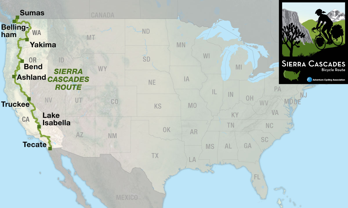
The Sierra Cascades Bicycle Route runs roughly parallel to the Pacific Crest National Scenic Trail along the Cascade Range and Sierra Nevada from the Canadian border to the Mexican border. This route is characterized by volcanoes, long stretches of forested countryside, busy towns, deserts, orchards and everything in between.

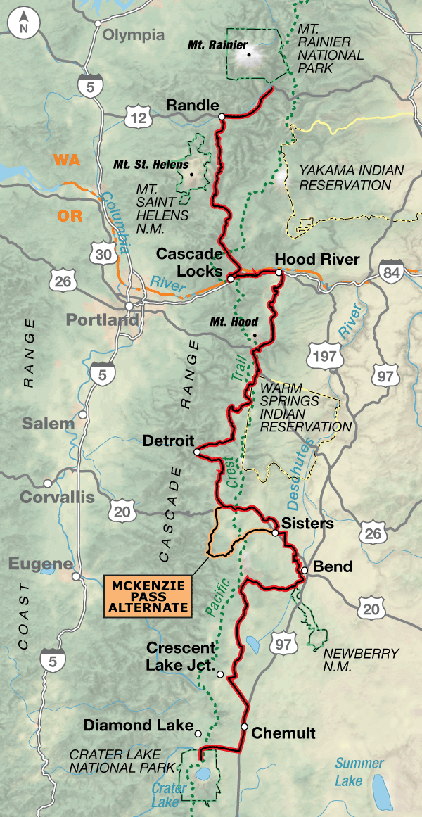
Section 1 begins at the Peace Arch Historical State Park next to the Canadian/U.S. border in Blaine, Washington. The first 30 miles of the route stays low on the coastal plain as it meanders through Bellingham, an outdoorsy college town that boasts train, plane and bus services. In Sedro-Woolley the route joins the Skagit River and parallels State Highway 20, which are followed eastward and upward into the main heart of the Cascade Range. Along the entire route you’ll cross 20 passes and 25 Pacific Crest Trail crossings, though some of these are unmarked. Due to heavy snow, State Highway 20 through the North Cascades National Park is usually only open between late April and late November. From Sedro-Woolley to Yakima this route shares the same routing with our Northern Tier and Washington Parks routes. On the east side you’ll be traveling through orchard country, where the roads will get busier during harvest times. West of Yakima the route heads to Mt. Rainier National Park. A spur is shown to the Paradise Visitor Center within the Park. Expect heavy traffic in and near the Park from June through August.
After Mt. Rainier National Park, the route runs south through many miles of national forest land on lightly-trafficked roads to the wind surfing area of the Columbia Gorge. The busy roads along the Columbia River will have tourist, recreational, and commercial traffic. There are 6 miles of riding on the shoulders of I-84 due to the fact that there are no other roads to use along the river. At Hood River, Oregon, the route turns south, circling around the eastern and southern flanks of Mt. Hood. From there you’ll ride through another long stretch of national forest land until reaching the suburbs of Bend, on the dry side of the Cascades. Stock up here because there’s one more long stretch of national forest land with its recreation opportunities, so expect more traffic on weekends. Crater Lake National Park is the endpoint of section 2, and again, expect heavier traffic on the road through the Park. The 59.7-mile McKenzie Pass Alternate follows paved state highways. It is more scenic, has less traffic, and offers a great view at the top of the pass in all directions. This section intersects the Lewis & Clark Bicycle Trail in Hood River and the TransAmerica Trail in Sisters, Oregon.
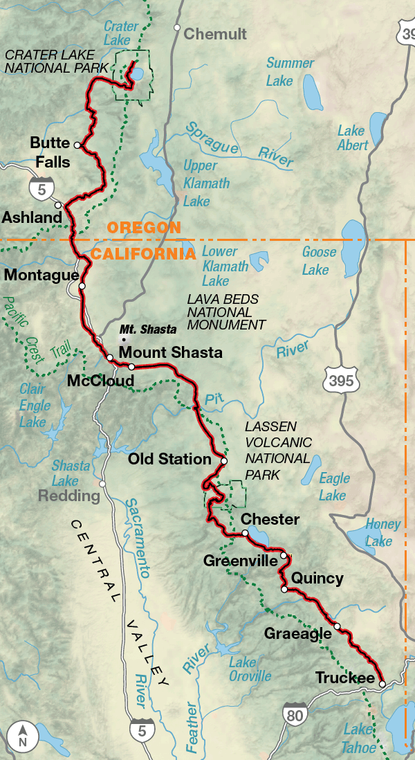
On section 3, after leaving the spectacular scenery of Crater Lake, the route continues south to Ashland, Oregon, home of the Oregon Shakespeare Festival. Then it’s across the border into California toward towering Mt. Shasta in the distance. You’ll have to ride on the shoulders of I-5 for 8.4 miles, again due to the fact that there are no other roads to use. You’ll bike through the remains of volcanic history in Lassen Volcanic National Park and end near the California/Nevada state line in Truckee. Reno, Nevada is located about 30 miles northeast and is a good connection point if you want to start the route at midpoint. Search the internet for available shuttle services.
Leaving Truckee, you’ll circle the western half of Lake Tahoe, then climb into the Sierra Nevada. Several of the passes on this section are closed during the winter, and might not open until late spring/early summer if it’s been a heavy snow year. You can check road opening dates on the California Department of Transportation’s website listed on the map. There’s a 66.2-mile stretch of riding U.S. 395, a major thoroughfare on the eastern side of the range. At Lee Vining, you’ll leave U.S. 395 and head west over Tioga Pass into Yosemite National Park. Expect heavy traffic in the parks during the summer tourist season. There are technically three national parks on this section, Yosemite, Kings Canyon, and Sequoia, but the last two are administered together. When traveling through you may want to build in some extra days to explore activities off the bike like climbing in Yosemite or hiking the Trail of a Hundred Giants in the Giant Sequoia National Monument. Lake Isabella, the endpoint for section 4, is located northeast of Bakersfield. This section intersects the Western Express Bicycle Route in Woodfords, California.
Lakes, mountains, valleys, and deserts, section 5 has them all! Highlights include the Mohave Desert, the San Gabriel Mountains, the San Gorgonio Mountains, the Anza-Borego Desert and the rustic small town of Idyllwild against the background of the San Jacinto Mountains. There are also plenty of scenic byways on the route beginning with the Angeles Crest, then the Rim of the World, and finally the Sunrise Scenic Byway. Remember that the megalopolis of Los Angeles and its surrounding cities isn’t too far to the west so expect higher levels of traffic near these byways, especially on weekends. The route ends at Tecate at the Mexican border. This section intersects with the Southern Tier Bicycle Route in Pine Valley, California.
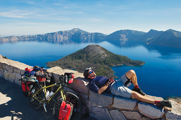
Photo by Gregg Bleakney
The Sierra Cascades route lets you warm up slightly before the first major climb to Rainy Pass at 4,855 feet. Once you cross to the eastern side of the Cascades, the route will be rolling and following river valleys until Old Blewett Pass. West of Yakima, Washington, is where the climbing begins to approach Mt. Rainier National Park. The route begins climbing and descending passes until the Columbia River Gorge where it’s mostly level riding, then there will be more climbs and descents south of Mt. Hood all the way to Crater Lake National Park. On section 3, and at the beginning of section 4, the route stays on the eastern side of the Cascade Range but still expect rolling terrain. You’ll climb into the Sierra Nevada south of Lake Tahoe (more passes), then stay at slightly higher elevations along U.S. 395. Tioga Pass, at 9,945 feet, is the eastern entrance to Yosemite National Park and is the highest pass along the route. As you continue southward, the route continues to go up and down and becomes more rolling as you reach the border.
| Sierra Cascades - Main Route | ||||
|---|---|---|---|---|
| Section | Distance | Elevation | Total Climb | Avg. Climb/mile |
| Total | 2441.1 miles | Minimum: 0 ft.Maximum:9,945 ft. | 195,975 ft. south bound194,310 ft. north bound | 80 ft. per mi. south bound80 ft. per mi. north bound |
| 1 | 484.0 miles | Minimum: 0 ft.Maximum:5,460 ft. | 27,480 ft. south bound26,340 ft. north bound | 57 ft. per mi. south bound54 ft. per mi. north bound |
| 2 | 452.5 miles | Minimum: 75 ft.Maximum:6405 ft. | 32,715 ft. south bound28,245 ft. north bound | 72 ft. per mi. south bound62 ft. per mi. north bound |
| 3 | 459.6 miles | Minimum: 1,875 ft.Maximum:8,515 ft. | 33,385 ft. south bound33,370 ft. north bound | 73 ft. per mi. south bound73 ft. per mi. north bound |
| 4 | 559.4 miles | Minimum: 460 ft.Maximum:9,945 ft. | 52,575 ft. south bound55,910 ft. north bound | 94 ft. per mi. south bound100 ft. per mi. north bound |
| 5 | 485.6 miles | Minimum: 1,280 ft.Maximum:8,445 ft. | 49,820 ft. south bound50,445 ft. north bound | 103 ft. per mi. south bound104 ft. per mi. north bound |
| Sierra Cascades Alternates | ||||
|---|---|---|---|---|
| Name | Section | Distance | Total Climb | Avg. Climb/mile |
| Blewett Pass Alternate | 1 | 13.1 miles | 1615 ft. south bound1,095 ft. north bound | 123 ft. per mi. south bound84 ft. per mi. north bound |
| Mt. Rainier N.P. Spur | 1 | 21.1 miles | 4,155 ft. south bound1000 ft. north bound | 197 ft. per mi. south bound47 ft. per mi. north bound |
| McKenzie Pass Alternate | 2 | 59.7 miles | 4,450 ft. south bound5,015 ft. north bound | 75 ft. per mi. south bound84 ft. per mi. north bound |
| Big Bear Lake Alternate | 5 | 8 miles | 440 ft. south bound470 ft. north bound | 55 ft. per mi. south bound59 ft. per mi. north bound |
Services are generally good along the Sierra Cascades Route, though there will be a few gaps without bike shops. You’ll need to do some careful planning on section 1 through North Cascades National Park.
Since most of this route traverses recreation areas, whether they are national or state parks, national monuments, or U.S. Forest Service lands, you will need to plan ahead for your overnights. It’s difficult to find camping without reservations in Yosemite, King’s Canyon, and Sequoia parks. The areas around Lake Arrowhead and Big Bear Lake are also magnets for summer recreationists. Check opening/closing dates of roads over the passes if you plan on beginning your trip early or later in spring or fall.
This route is best ridden in late spring to mid-fall (typically June to September), though the southern sections might be best avoided in the middle of summer. Due to heavy snow, North Cascades Highway/State Route 20 in North Cascades National Park is usually closed mid-November to mid-April, though the park remains open with limited access. For an opening date call the Park at (360) 856-5700. You’ll need to do some careful planning on section 2 due to three long stretches with very minimal services. In the northernmost segment of section 2, Forest Rd. 25 is passable only during months when it’s not snowing. Usually the road opens around July 1. Rim Dr. in Crater Lake National Park is generally closed in early October til mid-June. Similarly, Angeles Forest Hwy./FR N3 and Angeles Crest Hwy./State Route 2 are also typically closed. You can call the Los Angeles River Ranger District at (818) 899-1900, ext. 221, for the status of FR N3 and see the California DOT website for the status of State Route 2.
Some campgrounds will charge a cyclist traveling alone less if they have hiker/biker sites, but often they will charge the price of a regular tent or RV site, and that can easily be $10-$40/night (higher in tourist areas). The maps list churches that have opened their doors to cyclists, but they aren’t all that closely spaced. If you’re friendly and ask around, you can often get yourself invited to camp in a yard. Our routes sometimes go through national forests and you are allowed to camp anywhere on national forest land as long as you “pack it in, pack it out.” Many city parks are free to camp in.
You may also wish to sign up with Warmshowers, a reciprocal hospitality site for bicycle travelers, for other overnight options.
Route Highlights
Sierra Cascades Highlights
- North Cascades National Park, Section 1
- Mt. Rainier National Park, Section 1
- Columbia River Gorge National Scenic Area, Section 2
- Crater Lake National Park, Sections 2 and 3
- Oregon Shakespeare Festival, Section 3
- Hat Creek Radio Observatory, Section 3
- Lassen Volcanic National Park, Section 3
- Lake Tahoe, Section 4
- Travertine Hot Springs, Section 4
- Yosemite National Park, Section 4
- Kings Canyon and Sequoia National Parks, Section 4
- Giant Sequoia National Monument, Section 4
- Angeles Crest Scenic Highway, Section 5
- Rim of the Wold Scenic Byway, Section 5
- Big Bear Lake, Section 5
- Sunrise Scenic Byway, Section 5
More Route Resources
- U.S. Bicycle Route System
- How to Travel with your Bike on Amtrak
- U.S. Bicycle Routes (Washington)
- No-Turn-Away Bike Camping Policies (Washington)
- Peace Arch Historical State Park (Washington)
- North Cascades Highway (State Route 20) status (Washington)
- Cascade Trail (Washington)
- Yakima Greenway Trail (Washington)
- Columbia River Gorge Bike Map (Oregon)
- State Highway 242 McKenzie Pass status (Oregon)
- Twin Bridges Scenic Bikeway (Oregon)
- Cascade Lakes Scenic Highway status (Oregon)
- Rim Drive status (Crater Lake National Park)
- Park and Road Conditions (Lassen Volcanic National Park)
- Plumas Transit, bus between Chester and Quincy (California)
- Plumas County Tourism Council (California)
- Great Shasta Rail Trail (California)
- Lake Almanor Recreation Trail (California)
- California DOT Mountain Pass Closure dates
- California DOT State Highway Status
- Anza-Borrego Desert State Park (California)
- Connect and share photos with other riders on Instagram: #acaSierra
Updates to Recently Released Maps
If you are planning a bike tour, be sure to get the most recent map updates and corrections for your route by selecting the route, and the appropriate section(s), from the drop-down menu below.
Over time maps become less useful because things change. Every year Adventure Cycling’s Routes and Mapping Department create map updates and corrections for every map in the Adventure Cycling Route Network, which now totals 52,047 miles. With the help of touring cyclists like you, we receive updates on routing, services, camping, and contact information. Until we can reprint the map with the new information, we verify the suggested changes and publish corrections and updates here on our website.
PLEASE NOTE: Covid has been particularly hard on the small businesses along our routes. While we do our best to keep the maps and these online updates current, you may encounter more closed businesses and longer stretches with limited or no services.
Refer to these updates for the most current information we have and submit reports of changes to the Route Feedback Form for the cyclists coming after you.
NOTE: Map updates and corrections only pertain to long term changes and updates. For short term road closures, please see the Adventure Cycling’s Routes Temporary Road Closures discussion in our Forums.


