Vancouver Crossing Loop

The Vancouver Crossing Loop is DIGITAL-ONLY. No paper maps are produced for this route. This route is available digitally.
A Route as Varied as the Riders.
The Vancouver Crossing Loop begins at Clover Point in Victoria, British Columbia, a windswept perch on the edge of the Salish Sea where a small marker designates “Point Zero” of the Trans Canada Trail, the longest multi-use trail network in the world. From this shoreline, the route follows the southern tip of Vancouver Island through landscapes shaped by both natural forces and human history. The coast here has long been a place of salmon runs, tidal harvesting, maritime trade, and shifting cultural intersections.

In Victoria, the route passes Fisherman’s Wharf, a colorful floating community where seafood stalls, houseboats, and tour boats are anchored in the harbor. The scent of grilled halibut mingles with salt air, and marine life is often visible just below the docks. This area lies within the traditional and unceded territories of the Lekwungen (Songhees and Esquimalt) Peoples, and interpretive signs and public art share aspects of their living culture and deep connection to the land and waters.
A ferry crossing connects Vancouver Island to the Lower Mainland, opening a new stretch of coastal riding. The route travels through Steveston, once one of the busiest fishing ports in the province. The Gulf of Georgia Cannery National Historic Site preserves the history of a diverse workforce —Japanese, Chinese, Indigenous, and European — whose labor sustained a booming fishing and canning industry. Just upriver, Finn Slough offers a very different glimpse of the past, with weathered stilt houses and tidal channels evoking a slower, more precarious way of life along the Fraser River.
The shoreline in this part of the route is defined by ecologically rich wetlands, including Boundary Bay, Roberts Bank, and Sturgeon Bank Wildlife Management Areas. These intertidal zones are critical stopovers on the Pacific Flyway, drawing tens of thousands of migratory birds each spring and fall. Visitors may see flocks of sandpipers and dunlins, along with raptors such as the bald eagle, peregrine falcon, and northern harrier.
Approaching Vancouver, the route moves into one of the most culturally diverse cities in the world, where over half the population is made up of first-generation immigrants. Neighborhoods, markets, and storefronts reflect a wide range of traditions, and food culture is a highlight, with offerings that include Punjabi sweets, Chinese dumplings, and the rich, layered sweetness of the Nanaimo bar.
The route continues into North Vancouver via the SeaBus passenger ferry toward the historic Shipyards district. Once a center of wartime shipbuilding during the Second World War, these docks produced vessels that supported the Allied effort in the Pacific. Today, the area has been redeveloped with public spaces, markets, and waterfront paths that still retain a sense of its industrial heritage.
The return to Vancouver Island brings a shift in scenery as forests close in along the path. These are largely second and third-growth stands, but the remnants of old-growth Douglas fir remain visible in the massive, moss-covered stumps that line the trails. Logging roads and railways have been converted into recreational paths, and the scent of cedar is carried on the wind. The layered history of extraction, regeneration, and conservation is written into the land itself.
Continuing south, the trail approaches Langford, where Hatley Castle stands surrounded by manicured lawns, Japanese gardens, and imported plantings. Built in the early 20th century, the castle has served as both a military college and the home of Royal Roads University. Its architecture and grounds provide a striking example of Edwardian estate design on the Pacific coast.
The Vancouver Crossing Loop weaves together natural beauty, layered histories, and living cultures. From coastal wetlands alive with birdlife to the bustling streets of one of North America’s most multicultural cities, and from quiet fishing villages to forests reclaiming old industrial corridors, the route offers a multidimensional perspective on a region shaped by both land and sea for thousands of years.
CC Image courtesy of Alastair Smith on Flickr
TERRAIN
The route is generally flat from Victoria to downtown Vancouver, aside from a short, steep hill in Pacific Spirit Regional Park. West Vancouver brings some rolling hills, which can be bypassed via Marine Drive if you prefer an easier option. Back on Vancouver Island, the terrain grows hillier on the country roads between Nanaimo and Duncan. The Cowichan Valley Trail, being an old railroad grade, offers gentle and gradual climbs and descents between Duncan and Shawnigan Lake. The most challenging grades come on the Malahat Connector and Sooke Hills Wilderness Trail between Shawnigan Lake and Langford. While the climbs aren’t especially long, they are quite steep, and you will need to walk your bike in places.
The Vancouver Crossing Loop is approximately 70% completely car-free, on either fully separated bike paths or protected bike lanes. The majority of the remaining 30% is on very low traffic residential and rural roads with low speed limits. Only a small percentage, about 10% of the overall route, is on paved roads with higher speed limits (35-55 mph) that can be considered “busier”, and many of these roads feature wide shoulders or designated bike lanes (unprotected). Do keep in mind that you may need to travel slightly off-route to reach accommodations and services, which may affect these percentages. This route has lots of great access to services though, so you typically don’t need to travel very far!
Roughly 60% of the route is paved, and 40% is unpaved. The gravel roads and bike paths are generally smooth and well maintained, though the Sooke Hills Wilderness Trail features looser, chunkier gravel. For the best ride experience overall, we recommend a gravel or touring bike equipped with 42mm or wider tires.
NOTE: ferries have been excluded from metrics.
| Vancouver Crossing Loop | ||||
|---|---|---|---|---|
| Section | Distance | Elevation | Total Climb | Avg. Climb/mile |
| Total | 246.7 miles counterclockwise 245.5 miles clockwise miles | Minimum: 0 ft.Maximum:1,480 ft. | 11,461 ft. counterclockwise10,439 ft. clockwise | 46 ft. per mi. counterclockwise43 ft. per mi. clockwise |
LOGISTICS
The route formally begins and ends in Victoria, but you can start and finish anywhere on the loop that is convenient to you. Victoria is accessible from the United States via the Black Ball Ferry Line from Port Angeles or the Victoria Clipper from Seattle. If flying, Victoria International Airport offers the easiest access to the route, but Vancouver International Airport is often the cheaper option. You can also reach the route by train at Pacific Central Station in downtown Vancouver, served by the Amtrak Cascades route (U.S.) and VIA Rail Western Canada Route.
The route was originally designed and researched counterclockwise but can be ridden in either direction. If starting and ending in Victoria, riding in the counterclockwise direction will save the most scenic, challenging, and rewarding portion for last (between Lake Cowichan and Langford).
This route can be ridden anytime between late spring to early fall (typically early May to September). Unpaved portions of the route may be muddy when wet. Regardless of weather, a gravel or touring bike with 42mm tires or wider is recommended for this route.
There are three ferries on the route: Swartz Bay to Tsawwassen (1 hr 34 min), the SeaBus across Vancouver Harbor (12 min), and Horseshoe Bay to Departure Bay (1 hr 42 min). For the two longer ferries, plan to arrive 30-60 minutes before departure. Food and drinks are available onboard, which can be logistically helpful if you want to schedule your ferry crossing around mealtime. Reservations are available but not required. The SeaBus Ferry runs every 15 minutes from early in the morning to late at night.
Services are sparse along the route for 60 kilometers (37 miles) between Tsawwassen and Steveston, despite travelling through a mostly urbanized area. For lunch, some fast-food restaurants can be found on Annacis Island, in Queensborough, and near the Steveston Highway crossing in Richmond.
If you are planning to camp, be aware that only two campgrounds on the mainland portion of the route offer tent camping (as of 2025): Tsawwassen RV Resort in Tsawwassen and Capilano River RV Park in North Vancouver. They are 83 miles apart, so you will likely need to plan for at least one night indoors in the Richmond or Vancouver area. Keep in mind that Vancouver is an especially expensive city, so expect higher costs for accommodations and other purchases. Camping on Vancouver Island is plentiful, but be sure to make reservations. The campgrounds can be very busy during the summer season. You may also wish to sign up with Warmshowers, a reciprocal hospitality site for bicycle travelers, for other overnight options.
The route between Duncan and Langford is bear country. Use caution, keep your distance, and carry bear spray especially if camping. Bear spray can be purchased in Duncan or Victoria/Langford depending on your direction.
The 76-kilometre (47-mile) stretch between Lake Cowichan and Langford is by far the most remote, scenic, and challenging portion of the entire route, but it’s also the most rewarding. The Malahat Connector and Sooke Hills Wilderness Trail south of Shawnigan Lake will require walking your bike up some short but very steep sections. Be sure to allow extra time for this section. There are no services on this portion of the route, so stock up on food, water, and supplies before entering the forest.
Vancouver Crossing Loop Highlights:
- Clover Point
- Beacon Hill Park
- Downtown Victoria
- Lochside Trail
- Swartz Bay to Tsawwassen Ferry through the Gulf Islands
- Watershed Park
- Steveston Village
- Pacific Spirit Regional Park
- False Creek/Granville Island
- Stanley Park/Seawall
- Downtown Vancouver
- SeaBus ferry
- The Spirit Trail
- Ferry from Horseshoe Bay to Nanaimo
- Bowen Park
- Colliery Dam Park
- Ladysmith & Chemainus
- Cowichan Valley Trail
- Lake Cowichan
- Sooke Hills Wilderness Trail
- Goldstream Suspension Bridge
- Hatley Castle
More Route Resources:
- Galloping Goose Trail
- Lochside Regional Trail
- The Flight Path multi-use trail
- British Columbia Ferries
- Travelling with your bike on BC ferries
- Boundary Bay Dyke Trail
- Delta South Surrey Regional Greenway
- Watershed Park
- West Dyke Trail
- Stanley Park
- SeaBus
- The Spirit Trail
- Cowichan Valley Trail
- Cowichan River Provincial Park
- Sooke Hills Wilderness Trail
- E&N Rail Trail
RIDING CONDITIONS
The Vancouver Crossing Loop begins and ends at Clover Point in Victoria. On clear days, you will be treated to views of the snow-capped Olympic Mountains in Washington across the Strait of Juan de Fuca. The route through Victoria, Vancouver Island’s largest city and the capital of British Columbia, travels along dedicated bike paths and bicycle-friendly streets. The downtown area can be congested, so stay alert for vehicles and pedestrians.

Clover Point. CC Image courtesy Alex Costin on Flickr
After crossing the Johnson Street Bridge over the Victoria Harbor, you’ll ride onto the Galloping Goose Regional Trail, a multi-use trail originally built as a freight railway during World War I. At the Switch Bridge (a 100-metre span over the Trans-Canada Highway), the route veers onto the Lochside Regional Trail. This picturesque, converted railway connects Victoria to the Swartz Bay ferry terminal as it meanders past wetlands, farmlands, beaches, and suburban neighborhoods. While much of the trail offers scenic off-road paths, some sections follow paved or gravel public roads shared with vehicles and farm equipment. As the surroundings become more rural, be on the lookout for horses on the trail. Slow down, announce your presence, and pass cautiously once the rider indicates it’s safe to do so.
The seaside town of Sidney offers shopping, dining, lodging, and several attractions for visitors. To the west, the Victoria International Airport is easily accessible via The Flight Path multi-use trail.
Plan to arrive at the ferry terminal in Swartz Bay 30-60 minutes before your scheduled departure. See advcy.link/bikeBCferries for cyclist travel tips on B.C. ferries. The sailing time to Tsawwassen is approximately 1 hour and 34 minutes. Food and drinks are available onboard. Sit back and enjoy the view of the Gulf Islands as you cross the Strait of Georgia to the mainland.
Upon arriving in Tsawwassen, bikes disembark from the ferry before vehicles, but you’ll still be sharing the causeway with fast-moving traffic as cars follow closely behind. The route uses a narrow, curb-protected path along the southern edge of the causeway, but bike lanes are available in both directions if you prefer to ride on the road.
After a short ride through residential neighborhoods, the route transitions out of civilization onto the gravel Boundary Bay Dyke Trail, a scenic path popular with birdwatchers that traces the wetlands of Boundary Bay Wildlife Management Area. Local farms use the trail to access nearby fields, so be respectful of any machinery or equipment you may encounter. There is little shade on this section, and if the weather is hot and dry, the trail can be dusty. There are few services on the route between Tsawwassen and Steveston, a distance of about 60 kilometers (37 miles).
The Delta South Surrey Regional Greenway provides a connection to the Lower Trail through Watershed Park, Delta’s largest recreation area, featuring 11 kilometers (7 miles) of forested gravel trails for mountain biking, hiking, and horseback riding. The North Delta Greenway completes this section before crossing the Fraser River. Both the Lower Trail and North Delta Greenway can be muddy during wet weather, and nearby residential roads can be used as a paved alternate. Be aware that these trails parallel a high-speed railway and trains frequently use the tracks. Do not cross except at designated public crossings.
The Alex Fraser Bridge has separate bike paths for northbound and southbound travel that follow the flow of traffic, and the route will direct you to the correct side based on your direction. However, construction occasionally closes one side, requiring cyclists traveling in both directions to share the same path. In all cases, stay alert for oncoming bike traffic on the narrow bridge path. Ride slowly, especially on the downhill side, as the path makes several jogs around the bridge towers and suspension cables. Consider walking your bike in poor weather conditions. The surface can be slippery when wet.
Westminster Highway is very busy, but the route uses a well-protected bike path and frontage road to avoid riding directly with traffic. Sidaway Road and Blundell Road are narrow two-lane roads that can be very busy with commuters. Although the speed limit is low (50 kmh/31 mph), the tight space and ditches on either side can make this section feel uncomfortable. It is only a 3.2-kilometer (2-mile) stretch, but it’s still best to avoid riding here during rush hour if possible.
The shaded Shell Road and Horseshoe Slough Trails guide you back toward the Fraser River and into the community of Steveston. This charming fishing village is rich in history and makes a great stop for lunch or an overnight stay. The West Dyke Trail wraps around Richmond, skirting the wetlands and estuaries of Sturgeon Bank Wildlife Management Area. After a brief stretch through a busy urban and industrial zone near Vancouver International Airport, the route crosses into Vancouver on the North Arm Bridge Bikeway with views of the Fraser River below.
As you enter Vancouver, you’ll encounter increased traffic and congestion. Stay alert, ride confidently, and walk your bike if necessary. The Arbutus Greenway slices through the city along a former railway corridor with easy access to nearby services. The paved path is divided for pedestrians and cyclists, a common layout you’ll encounter throughout the rest of Vancouver. After passing through the vibrant village of Kerrisdale, the route leaves the greenway to head west through a quiet tree-lined residential neighborhood. Pacific Spirit Regional Park is an oasis of nature featuring a lush forest of towering trees and delicate ferns. Ride with care — these trails are shared with hikers, fellow cyclists, horseback riders, and off-leash dogs. Use caution when crossing West 16th Avenue and University Boulevard, as cross traffic does not stop. This area also introduces the first hills of the route, some of which are steep enough that you may prefer to dismount and walk.
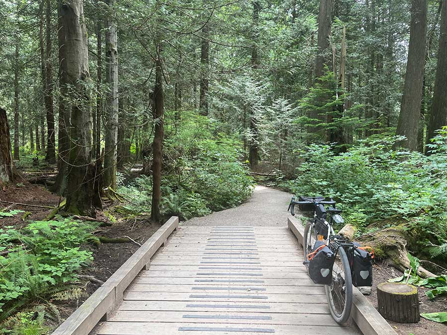
Pacific Spirit Regional Park. Photo by Josh Bowden.
The route levels out as it passes several sandy beaches complete with lifeguards, concessions, and scenic views of the Vancouver skyline. Follow the green signs for the Seaside Bike Route from here to downtown. The route wraps around False Creek, a narrow inlet lined with museums, parks, and marinas. Consider a short detour to Granville Island, a popular destination featuring shops, restaurants, theatres, art galleries, and nightlife. While the bike paths in this area can get crowded with tourists, they are separated from pedestrian walkways to help maintain a smoother flow. Be sure to follow all posted signage, and slow down or walk your bike if the paths become too crowded.
The Seawall Bike Path circling Stanley Park is a highlight of the route, renowned as the longest uninterrupted waterfront path in the world. It’s a one-way path that circles the peninsula counterclockwise, so be sure to follow directional signs.

Stanley Park Seawall. Photo by Josh Bowden.
The SeaBus ferry runs all day every 15 minutes from downtown Vancouver to North Vancouver. Bikes with trailers are not permitted; use the Lions Gate Bridge as an alternate way to cross the harbor if you are towing a trailer.
From North Vancouver to West Vancouver, the route follows portions of the Spirit Trail along the waterfront. The route then climbs into the hills for a rollercoaster ride along quiet residential streets, with occasional glimpses of the sea through the trees. For a less hilly route, Marine Drive provides a flatter alternative that’s popular with local cyclists, though it will have more traffic.
Plan to arrive at the ferry terminal in Horseshoe Bay 30-60 minutes before your scheduled departure. See advcy.link/bikeBCferries for cyclist travel tips on B.C. ferries. The sailing time to Departure Bay (Nanaimo) is approximately 1 hour and 42 minutes. Food and drinks are available onboard.
The route through Nanaimo follows a combination of bike paths and residential streets. Navigation can be a bit tricky here, as some bike paths are not well-signed—so be sure to follow the route closely on your device. Enjoy the scenery of Colliery Dam Park before connecting to the Parkway Trail, a paved, tree-lined path alongside Nanaimo Parkway.

Colliery Dam Park in Nanaimo. Photo by Josh Bowden.
South of Nanaimo, the route loops into the foothills along rural country roads. Cedar Road can be busy but generally has good shoulders, and drivers are accommodating. A short ride (5.5 km/3.4 mi. for counterclockwise, 2.4 km/1.5 mi. for clockwise) on the Trans-Canada Highway is necessary to approach the town of Ladysmith. The shoulders are very wide in both directions, but stay alert where side roads enter the highway. Ladysmith features all the warmth and charm of small town living with a full range of services, amenities, and attractions.
The Cowichan Valley Trail from Ladysmith to Chemainus is unpaved and travels through parkland and past residential backyards. Chemainus is easy to miss from the trail, but well worth a stop to enjoy the town’s shops, restaurants, and 50+ murals. South of Chemainus the route follows rural paved roads with some short but steep climbs. In Duncan, the route rejoins the Cowichan Valley Trail and heads into the forest. A pedestrian bridge over the sparkling waters of the Cowichan River brings you into the summer tourist town of Lake Cowichan, popular for its water sports. Stock up on food, water, and supplies here; it is 76 kilometers (47 miles) to the next services in Langford. Potable water is available at Glenora Trails Head Park if needed. Depending on battery range, e-bike riders may need to detour into the Shawnigan Lake area to recharge.
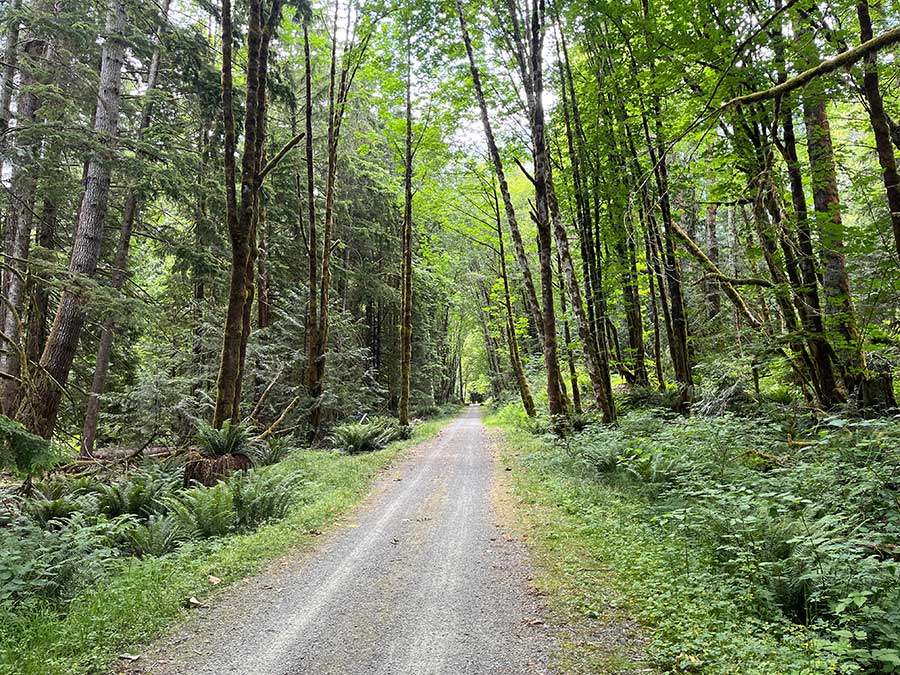
Cowichan Valley Trail. Photo by Josh Bowden.
The stretch between Lake Cowichan and Langford is by far the most remote, scenic, and challenging portion of the entire route, but it’s also the most rewarding. Along the way you’ll encounter several river crossings, towering trestles, remnant old-growth forests, waterfalls, and even a suspension bridge. This section begins by continuing on the Cowichan Valley Trail, which generally has a good gravel surface and gentle grades. South of Shawnigan Lake, the route joins the Malahat Connector and Sooke Hills Wilderness Trail and the terrain becomes significantly more mountainous. Expect some very steep climbs and descents that will require walking your bike for a short distance and beware of loose gravel. Be sure to allow extra time for this section. Bears frequent the area between Duncan and Langford, so use caution, keep your distance, carry bear spray, and hang your food if camping. Camping is not permitted along the Cowichan Valley Trail or Sooke Hills Wilderness Trail except at designated campgrounds.

Sooke Hills Wilderness Trail. Photo by Josh Bowden.
The route returns to civilization rather abruptly in Langford, where it connects to the Galloping Goose Trail and E&N Rail Trail for the final stretch through neighborhoods and shopping centers back to Victoria. Several busy intersections require awkward diagonal crossings. Use the crosswalks and try to avoid riding during rush hour.
The route concludes in Victoria with a scenic ride past the impressive British Columbia Parliament Buildings, the lively Fisherman’s Wharf, and the Dallas Road Waterfront before completing the loop at Clover Point.
LAND ACKNOWLEDGEMENT
As we travel by bicycle through these lands, we pause to reflect on our relationship with this place. We ride with respect and honor for the Indigenous peoples who have stewarded these shores, forests, and waters since time immemorial. We commit to caring for this land by staying on paths, leaving no trace, and listening to the wisdom of the Coastal Salish First Nations, including the Lək̓ʷəŋən (Songhees and Esquimalt), SȾÁUTW̱ (Tsawout), W̱JOȽEȽP (Tsartlip), BOḰEĆEN (Pauquachin), W̱SIḴEM (Tseycum), sc̓əwaθenaɁɬtəməxʷ (Tsawwassen), xʷməθkʷəy̓əm (Musqueam), Sḵwx̱wú7mesh Úxwumixw (Squamish), Snuneymuxw, Stz’uminus, Halalt, Ts’uubaa-asatx, MÁLEXEȽ (Malahat), and others who call these territories home. May your journey be guided by respect, gratitude, and responsibility.
CLIMATE
This route travels through the mild coastal climate of southern Vancouver Island and the Lower Mainland, where temperatures are generally moderate year-round compared to most of Canada. Average summer highs range from the upper teens to mid-20s °C (60s & 70s °F). Lake Cowichan tends to be warmer in summer, often reaching the upper 20s °C (80s °F) and seeing less coastal breeze, which can make it feel hotter. Rain is most frequent from October through April, but short showers are still possible during the summer months. Afternoon sea breezes can pick up, especially near the water, while sheltered inland valleys like Lake Cowichan are generally calmer.
Updates to Recently Released Maps
If you are planning a bike tour, be sure to get the most recent map updates and corrections for your route by selecting the route, and the appropriate section(s), from the drop-down menu below.
Over time maps become less useful because things change. Every year Adventure Cycling’s Routes and Mapping Department create map updates and corrections for every map in the Adventure Cycling Route Network, which now totals 52,047 miles. With the help of touring cyclists like you, we receive updates on routing, services, camping, and contact information. Until we can reprint the map with the new information, we verify the suggested changes and publish corrections and updates here on our website.
PLEASE NOTE: Covid has been particularly hard on the small businesses along our routes. While we do our best to keep the maps and these online updates current, you may encounter more closed businesses and longer stretches with limited or no services.
Refer to these updates for the most current information we have and submit reports of changes to the Route Feedback Form for the cyclists coming after you.
NOTE: Map updates and corrections only pertain to long term changes and updates. For short term road closures, please see the Adventure Cycling’s Routes Temporary Road Closures discussion in our Forums.