Western Express

All aboard for scenery and adventure.
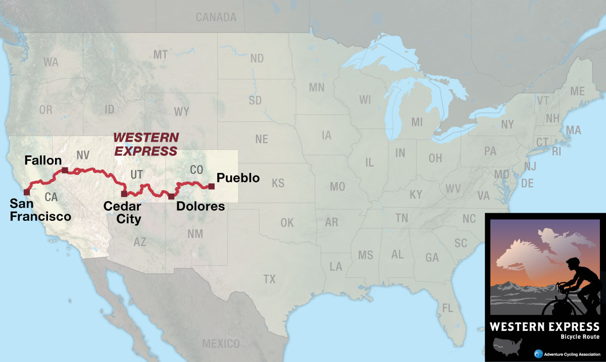
The Western Express Bicycle Route connects San Francisco, California, on the west coast to the TransAmerica Bicycle Trail in Pueblo, Colorado. It provides a shorter mileage option (468 miles less when compared to the TransAmerica Trail) on a central cross-country route but challenges the rider with extreme weather and riding conditions, as well as logistical obstacles. One’s efforts are rewarded, however, by experiencing some of the least visited and most magnificent areas of the American West.

From the metropolis of San Francisco, the Western Express Route passes through lush agricultural valleys and climbs over the Sierra Nevada. In Nevada it uses “The Loneliest Road in America,” a term coined some years ago by a Life magazine writer for U.S. Highway 50. The route then winds among the magnificent monuments and parks of southern Utah. It crosses the spine of the Rocky Mountains over numerous passes to end in Pueblo, Colorado, the gateway to the Great Plains.
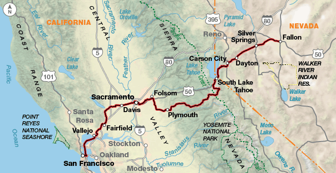
After the food and fun of San Francisco by the Bay, a relaxing ferry ride eliminates a hard day of urban cycling and deposits the cyclist in Vallejo. The route parallels an interstate and winds through suburbs to Fairfield and then passes through rolling, verdant agricultural areas before turning east. Urban riding conditions prevail along the section from Davis through Folsom. Separate bike paths, which start in Davis and extend through Sacramento to Folsom, provide welcome relief from busy surface streets. From there the route begins to climb the Sierra Nevada foothills to the 8,573 foot Carson Pass. It then descends into the historic mining region around Carson City, Nevada.
People watchers will enjoy a casino visit in Carson City, assuming you don’t plan to finance your trip there. Just west of South Lake Tahoe, the route joins U.S. Highway 50 into Fallon, where the challenging part really begins. A dozen climbs await the rider on “The Loneliest Road in America” as it traverses the roller-coaster range and basin country paralleling the route of the famous Pony Express. Nevadans are noted for their self-reliance, hospitality (as long as you are not a federal employee), and whimsical sense of humor as evidenced by such unique attractions as the “Post Impressionist ” (fence post) art between Baker and Lehman Cave in Great Basin National Park.
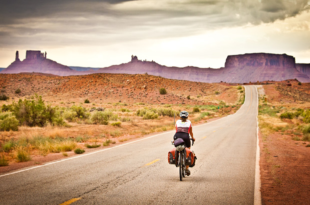
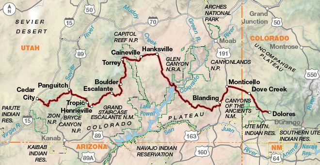
East of Cedar City, Utah, the route passes through some of the nation’s most isolated communities and several of its most spectacular scenic wonders. Take some time to explore Cedar Breaks, Escalante, and Natural Bridges National Monuments; Bryce Canyon and Capitol Reef National Parks; and Glen Canyon National Recreation Area. To even the most experienced of travelers, these natural sculptures, spires, buttes, and canyons are no less than humbling. The Utah portion of the route could be a worthy destination in itself. After passing through the bean-growing capital of the nation in southwestern Colorado, the route swings north and then east through the small tourist communities of the Rockies where one can always find an espresso and a ski hill, however modest. The route traverses forested mountains to Salida and from there into the narrow valley of the Arkansas River to Cotopaxi. Here the route leaves busy U.S. Highway 50 and winds through quiet wooded foothills until reaching Pueblo.
Photo by Adam Coppola
The route lets you warm up for 150 miles before the first major climb over Carson Pass at 8,573 feet. Nevada offers almost unlimited sight lines across wide valleys before ascending and descending a pass into the next valley. The terrain through central Utah becomes steeper, with grades varying from 6 percent to 14 percent. In Colorado the route follows several river valleys, though for the most part you’ll be either climbing or descending.
| Western Express - Main Route | ||||
|---|---|---|---|---|
| Section | Distance | Elevation | Total Climb | Avg. Climb/mile |
| Total | 1577.0 miles | Minimum: 0 ft.Maximum:11,320 ft. | 103,075 ft. east bound98,320 ft. west bound | 65 ft. per mi. east bound62 ft. per mi. west bound |
| 1 | 319.9 miles | Minimum: 0 ft.Maximum:8,595 ft. | 20,190 ft. east bound16,290 ft. west bound | 63 ft. per mi. east bound51 ft. per mi. west bound |
| 2 | 458.4 miles | Minimum: 3,890 ft.Maximum:7,720 ft. | 22,970 ft. east bound21,035 ft. west bound | 50 ft. per mi. east bound46 ft. per mi. west bound |
| 3 | 441.4 miles | Minimum: 3,705 ft.Maximum:10,600 ft. | 35,225 ft. east bound34,190 ft. west bound | 80 ft. per mi. east bound77 ft. per mi. west bound |
| 4 | 357.3 miles | Minimum: 4,650 ft.Maximum:11,320 ft. | 24,690 ft. east bound26,805 ft. west bound | 69 ft. per mi. east bound75 ft. per mi. west bound |
| Western Express Alternates | ||||
|---|---|---|---|---|
| Name | Section | Distance | Total Climb | Avg. Climb/mi |
| Carroll Summit Alternate | 2 | 57.9 miles | 4,015 ft. east bound2,910 ft. west bound | 69 ft. per mi. east bound50 ft. per mi. west bound |
This route can be ridden from mid-May through October, depending on weather. Carson Pass crosses over the Sierra Nevada at an elevation of 8,573 feet. Local conditions and mountain ranges affect winds, so it is difficult to predict any major wind patterns. Dust and sandstorms will occasionally occur in the deserts of Nevada and Utah. Sections 2 and 3 of this route (Nevada and Utah) are considered difficult due not only to steep terrain but also due to lack of water, temperature extremes (as high as 100 degrees Fahrenheit in the summer), and long mileages without services. >Snow can also fall at any time in the Rocky Mountains, and the highest pass is over 11,000 feet in Colorado.
While California is almost urban in availability of services, Nevada and Utah present special problems in obtaining water and food on a daily basis. Carrying a water filter is strongly advised for water access at miscellaneous reservoirs, creeks, and lakes at primitive campsites. In most cases, there are no homes or ranches between services. Call ahead to verify any services. Nevada and Utah are extremely dry, and few trees are available for shade. In Colorado, services are more easily found, though higher altitude services — from campground water to grocery stores — can close early depending on weather.
Some campgrounds will charge a cyclist traveling alone less if they have hiker/biker sites, but often they will charge the price of a regular tent site, and that can easily be $10-$20/night. The maps list churches that have opened their doors to cyclists, but they aren’t all that closely spaced. If you’re friendly and ask around, you can often get yourself invited to camp in a yard. Our routes sometimes go through national forests (moreso in the west) and you are allowed to camp anywhere on national forest land as long as you “pack it in, pack it out.” Many city parks are free to camp in.
You may also wish to sign up with Warmshowers, a reciprocal hospitality site for bicycle travelers, for other overnight options.
Route Highlights
Western Express Highlights
- Golden Gate National Recreation Area, Section 1
- U.S. Bicycle Hall of Fame, Section 1
- Great Basin National Park, Section 2
- Cedar Breaks National Monument, Section 3
- Bryce Canyon National Park, Section 3
- Grand Staircase-Escalante National Monument, Section 3
- Capitol Reef National Park, Section 3
- Glen Canyon National Recreation Area, Section 3
- Natural Bridges National Monument, Section 3
- Canyon of the Ancients National Monument, Section 3
- Telluride, Colorado, Section 4
- Monarch Pass, Section 4
- Black Canyon of the Gunnison National Park, Section 4
More Route Resources
- U.S. Bicycle Route System
- No-Turn-Away Bicycle Camping Policies (Nevada)
- U.S. Bicycle Routes 70 and 79 (Utah)
- U.S. Bicycle Route 50 (Nevada)
- San Francisco Bike Map and Walking Guide
- Golden Gate Bridge Bicycle and Pedestrian Access
- San Francisco Bay Ferry to/from Vallejo (California)
- Davis area/Yolo County bike rides (California)
- Sacramento Region Travel bike maps for Davis, Folsom, Sacramento and American River Bike Trail
- California DOT Road Conditions for Carson Pass/State Route 88
- Nevada DOT Bicycling Information
- Cedar City/Iron County Tourism Bureau (Utah)
- Colorado DOT Bicycle and Pedestrian Program
- Connect and share photos with other riders on Instagram: #acaWestExp
Updates to Recently Released Maps
If you are planning a bike tour, be sure to get the most recent map updates and corrections for your route by selecting the route, and the appropriate section(s), from the drop-down menu below.
Over time maps become less useful because things change. Every year Adventure Cycling’s Routes and Mapping Department create map updates and corrections for every map in the Adventure Cycling Route Network, which now totals 52,047 miles. With the help of touring cyclists like you, we receive updates on routing, services, camping, and contact information. Until we can reprint the map with the new information, we verify the suggested changes and publish corrections and updates here on our website.
PLEASE NOTE: Covid has been particularly hard on the small businesses along our routes. While we do our best to keep the maps and these online updates current, you may encounter more closed businesses and longer stretches with limited or no services.
Refer to these updates for the most current information we have and submit reports of changes to the Route Feedback Form for the cyclists coming after you.
NOTE: Map updates and corrections only pertain to long term changes and updates. For short term road closures, please see the Adventure Cycling’s Routes Temporary Road Closures discussion in our Forums.


