Chicago to New York City (CNYC)
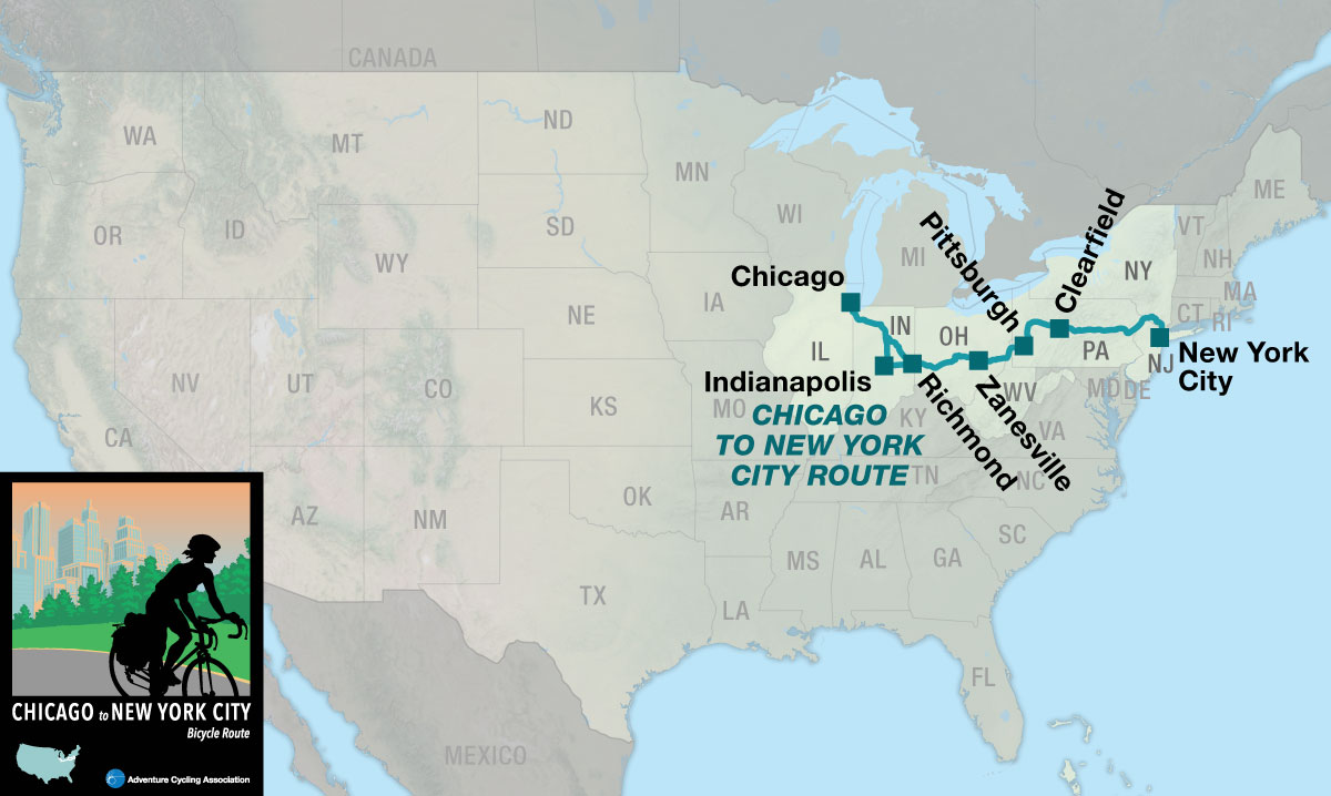
Chicago to New York City Route Chicago, IL to New York City, NY 4 Map Set GPX Data | Overview | Buy | Mobile App
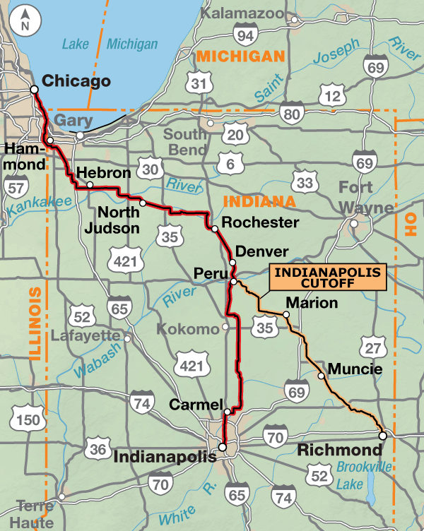
1. Chicago, IL to Indianapolis, IN Detail
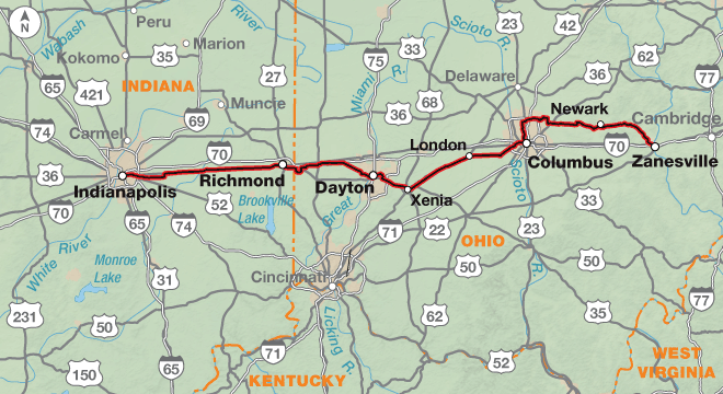
2. Indianapolis, IN to Zanesville, OH Detail
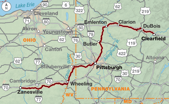
3. Zanesville, OH to Clearfield, PA Detail
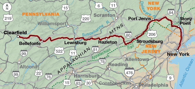
4. Clearfield, PA to New York City, NY Detail
Chicago to New York City Philadelphia Alternate Pittsburgh, PA to New York City, NY 2 Map Set GPX Data | Overview | Buy | Mobile App
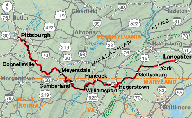
1. Pittsburgh, PA to Lancaster, PA Detail
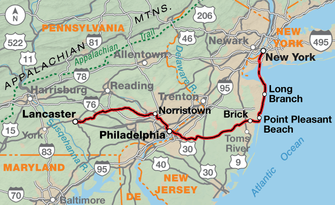
2. Lancaster, PA to New York City, NY Detail

Route Options

The Chicago to New York City Bicycle Route includes a main route and the Philadelphia Alternate, which stretches from Pittsburgh, Pennsylvania to New York City. This page describes the 1,160.3-mile main route from Chicago, Illinois to New York City, New York. If you choose to combine the main route with the Philadelphia Alternate the mileage is 1,172.9 miles. On section 3, in Pittsburgh, is the intersection where you’ll switch maps from following the main route to the Philadelphia Alternate.

To make an informed decision about whether to choose the main route or the Philadelphia Alternate, here is a list of the major differences.

  • Main route: more hills and short steep hills in eastern Pennsylvania and New York with more paved roads.
  • Philadelphia Alternate: 150 miles on the GAP, mostly unpaved on a crushed limestone surface, and 85 miles on the C&O Trail, mostly unpaved on a dirt surface which can be slick and hard to ride in wet conditions. The maximum grade is 1.5%. There are multiple tunnels. Eastern Pennsylvania is rolling while New Jersey becomes flatter the closer the route gets to the Atlantic Ocean.

The Windy City to the Big Apple

Cities, small towns, farmland, forests, roads, and trails — this route has it all! The Chicago to New York City Bicycle Route includes a main route and the Philadelphia Alternate, which goes between Pittsburgh, Pennsylvania and New York City. Heading east from Chicago you’ll go through Indianapolis, Columbus, and Pittsburgh. In Pittsburgh you can choose to follow the main route, which crosses Pennsylvania into New Jersey. It then enters New York City from the north. If you choose the Philadelphia Alternate you’ll ride the Great Allegheny Passage and a portion of the C&O Canal Trail in Maryland. After leaving Philadelphia, the route goes east to the New Jersey shore and ends with a ferry ride into New York City from the south.
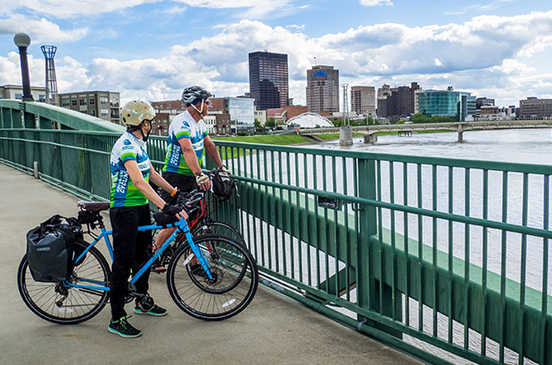
When combined with Bicycle Route 66, this route completes a cross-country link from Los Angeles, California all the way to New York City. It begins in downtown Chicago along Lake Michigan. You’ll be riding trails and city streets to make your way through Chicago and its suburbs, which extend into Indiana. The riding through Indiana is on flat to rolling terrain that originally supported the tallgrass prairie ecosystem. Indiana is characterized by small towns and mid-sized cities with ample services. The route follows several bike paths as it heads southward, including the North Judson Erie Trail, the Nickel Plate Trail, and the Monon Trail into downtown Indianapolis. The city has mostly one-way streets, but well signed bike lanes and paths are the norm.

The 103.7-mile Indianapolis Cutoff between Peru and Richmond saves 50 miles. Except for the first 20 miles of county roads to Converse and about 15 miles on county highways south of Jonesboro, the cutoff uses three rail trails. The Converse Junction Trail, the Sweetser Switch Trail, and the Cardinal Greenway take cyclists through Marion and Muncie and on to Richmond.

Leaving Indianapolis, the route follows designated bike routes into the eastern suburbs and then onto county roads. Central eastern Indiana and central western Ohio are flat with occasional rolling sections until you reach Columbus.

East of Richmond, Indiana, the route follows low-trafficked county roads to Brookville, Ohio and then joins the Wolf Creek Recreation Trail to Trotwood. On the west side of Dayton, you’ll ride rural residential roads and bike paths to the Great Miami River Trail through the downtown area. The Mad River Bikeway, the Creekside Trail, and the Ohio to Erie Trail provide almost continuous car-free riding from Dayton to Columbus. From Xenia to seven miles east of London, this section of route is also on the Underground Railroad Route.

In Columbus, the Camp Chase Trail and the Scioto Trail take you near downtown. The route then turns north following the Olentangy River along the Olentangy Trail, and bike lanes on residential streets. Further north the route passes through the Ohio State University campus and northern Columbus suburbs. East of the capital city you will encounter hillier terrain. The TJ Evans Trail and the Panhandle Trail take you into and out of Newark with a two-mile section on city roads through downtown. A state highway with good shoulders through rolling hills will then take you past the Dillon State Park into Zanesville, a mid-size town.

Eastern Ohio, West Virginia, and Pennsylvania get hillier as you enter the Appalachian Plateau region. This section of the route heads northeast and includes county and state highways, numerous bike paths, and occasional busy city streets in Pittsburgh and its suburbs. Oil and gas development has increased in this region, though in Ohio most of the development and truck traffic is north of the route. In eastern Ohio, the route travels rural county roads with no shoulders, and some with no centerlines. The lightly-trafficked state highways also have minimal to no shoulders. Roads can be winding. When crossing into West Virginia on the historic Wheeling Suspension Bridge, walk your bike on the sidewalk to avoid the grated deck. This was the first bridge, built in 1849, to cross the Ohio River. From Wheeling to Wellsburg, you’ll ride along the Ohio River for 17 miles on the Wheeling Heritage Trail, the Brooke Pioneer Trail, and the Wellsburg Yankee Trail. At Follansbee, the route climbs over a steep ridge before descending to the Panhandle Trail. Its surface is crushed limestone. The trail ends 24.6 miles later in Rennerdale, about eight miles southwest of Pittsburgh. A suburban highway with good shoulders carries you down to the Ohio River and then to the Three Rivers Heritage Trail system in Pittsburgh. This network of trails allows you to cross the Monongahela and Allegheny rivers and bypass downtown Pittsburgh traffic. The route between Etna and Emlenton is on rural county roads and state highways with variable shoulders amongst rolling hills.  At Emlenton, the route joins signed BicyclePA Route V on state and federal highways. With the exception of the busier urban streets in the towns of Clarion, Brookville, DuBois, and Clearfield, traffic is light.

Clearfield is located in north central Pennsylvania on the West Branch of the Susquehanna River. The route continues to follow signed BicyclePA Route V across the state to Delaware Water Gap on the state border with New Jersey. With exceptions through some towns, the route uses light to moderately-trafficked roads, most with minimal shoulders of 12-18 inches wide. East of Clearfield, you will transition from the Appalachian Plateau to the Ridge and Valley Appalachians. This belt forms a broad arc between the Appalachian Plateau and the Blue Ridge Mountains, and is characterized by long, even ridges with long continuous valleys in between. Most of the route follows the valleys, however, a couple ridge crossings provide steeper climbs (up to 10% grades) on narrow winding roads. Between Delaware Water Gap and Port Jervis, New York you’ll parallel the Delaware River through the Delaware Water Gap National Recreation Area. Roads are narrow and quiet, not well signed, and services are scarce. This section of route is also on the Atlantic Coast Bicycle Route. In New York, the route follows secondary state highways and rural roads to Goshen, where you pick up the Orange Heritage Trail to Monroe. Kanawauke Rd. through Harriman State Park is narrow and twisty and sees significant seasonal and weekend traffic. The residential boulevards connecting Harriman State Park to West Haverstraw are narrow and have grades exceeding 12% for approximately two to three miles. South of West Haverstraw, the route follows signed New York State Bicycle Route 9, a popular on-road route for New York City cyclists. It will take you to the George Washington Bridge to cross the Hudson River into Manhattan. A few blocks on city streets will drop you down to the Hudson River Greenway, which is a major bike commuter route into and out of the city. Pedestrian traffic on the bike path will increase significantly. The route ends at Battery Park, located at the southern tip of Manhattan Island. The park includes statues and memorials. Along the waterfront, Statue Cruises offers ferries to the Statue of Liberty and Ellis Island.

Photo by Saara Snow

This route includes a wide variety of terrain from flat to rolling farmland interspersed with swatches of forests. Eastern Ohio, West Virginia, and western Pennsylvania become hillier as you enter the Appalachian Plateau region. East of Clearfield, the land transitions from the Appalachian Plateau to the Ridge and Valley Appalachians. This belt forms a broad arc between the Appalachian Plateau and the Blue Ridge Mountains, and is characterized by long, even ridges with long continuous valleys in between. Most of the route follows the valleys, however, a couple of ridge crossings provide steeper climbs (up to 10% grades) on narrow winding roads. West of the Hudson River in New York, the residential boulevards connecting Harriman State Park to West Haverstraw are narrow and have grades exceeding 12% for short distances.

There are numerous rail trails on this route, and grades on them are typically less than 2%.

Chicago to New York City Route - Main Route
Section Distance Elevation Total Climb Avg. Climb/mile
Total 1160.3 miles Minimum: 0 ft.
Maximum:2350 ft.
51,600 ft. east bound
52,110 ft. west bound
44 ft. per mi. east bound
45 ft. per mi. west bound
1 230.8 miles Minimum: 690 ft.
Maximum:1230 ft.
3345 ft. east bound
3240 ft. west bound
14 ft. per mi. east bound
14 ft. per mi. west bound
2 274.6 miles Minimum: 690 ft.
Maximum:1230 ft.
6170 ft. east bound
6115 ft. west bound
22 ft. per mi. east bound
22 ft. per mi. west bound
3 295.8 miles Minimum: 625 ft.
Maximum:2350 ft.
20170 ft. east bound
19655 ft. west bound
68 ft. per mi. east bound
66 ft. per mi. west bound
4 359.1 miles Minimum: 0 ft.
Maximum:1860 ft.
21915 ft. east bound
23100 ft. west bound
61 ft. per mi. east bound
64 ft. per mi. west bound
Chicago to New York City Philadelphia Alternate
Section Distance Elevation Total Climb Avg. Climb/mile
Total 518.5 miles Minimum: 0 ft.
Maximum:2,735 ft.
15,405 ft. east bound
15,720 ft. west bound
30 ft. per mi. east bound
30 ft. per mi. west bound
1 338.7 miles Minimum: 225 ft.
Maximum:2,735 ft.
10,370 ft. east bound
10,320 ft. west bound
31 ft. per mi. east bound
30 ft. per mi. west bound
2 179.8 miles Minimum: 0 ft.
Maximum:680 ft.
5,035 ft. east bound
5,400 ft. west bound
28 ft. per mi. east bound
30 ft. per mi. west bound
Chicago to New York City Route Alternates
Name Section Distance Total Climb Avg. Climb/mile
Indianapolis Cutoff 1 103.7 miles 2,080 ft. east bound
1,735 ft. west bound
20 ft. per mi. east bound
17 ft. per mi. west bound

This route can be ridden from mid-spring to mid-fall (typically April to mid-September). Expect high temperatures and humid conditions during the summer. In Indiana, prevailing winds are from the southwest during most of the year. Watch for tornadoes in the spring. Due to changing local conditions, it is difficult to predict any major wind patterns along the remainder of the route.

Services are generally plentiful, though there will be occasional exceptions. Multiple bike shops are located in the larger metropolitan areas. To camp every night, you will need to plan your overnights carefully and ride off the route. Very few campgrounds are located on route.

Some cyclists may want to ride this route during the colors of autumn. If you do, call ahead to verify campground availability because many close after Labor Day. If staying indoors, make advance reservations.

Some campgrounds will charge a cyclist traveling alone less if they have hiker/biker sites, but often they will charge the price of a regular tent site, and that can easily be $10-$20/night. If you’re friendly and ask around, you can often get yourself invited to camp in a yard. Many small town city parks are free to camp in.

You may also wish to sign up with Warmshowers, a reciprocal hospitality site for bicycle travelers, for other overnight options.

Route Highlights

Chicago to New York City Route Highlights

  • Chicago Lakefront, Section 1
  • Hoosier Prairie State Nature Preserve, Section 1
  • Tippecanoe River State Park, Section 1
  • International Circus Hall of Fame and Museum, Section 1
  • Indianapolis Cultural Trail, Section 2
  • The National Road, Section 2
  • Dayton Aviation Heritage National Historical Park, Section 2
  • Battelle Darby Creek Metro Park, Section 2
  • Appalachian Plateau Region, Section 3
  • Wheeling Suspension Bridge, Section 3
  • Settlers Cabin Park, Section 3
  • Duquesne Incline, Section 3
  • Delaware Water Gap National Recreation Area, Section 4
  • Hickory Run State Park, Section 4
  • Harriman State Park, Section 4
  • Palisades Interstate Parkway, Section 4


RIDING CONDITIONS

The Chicago to New York City Bicycle Route begins in downtown Chicago along Lake Michigan. You’ll be riding trails and city streets to make your way through the city and its suburbs, which extend into Indiana. As with all cities, rush hours are to be avoided. For bike maps of Chicago see advcy.link/chibkmap.

U.S. Bicycle Route (USBR) 35 has been designated in Indiana. Portions of our route run concurrent with it. For more information and maps see advcy.link/inusbr.

The riding through Indiana is over flat to rolling terrain that originally supported the tallgrass prairie ecosystem. Efforts to restore the native prairie can be seen along many roadsides today.

Indiana is characterized by small towns and mid-sized cities with ample services. The route follows occasional bike paths as it heads southward. All bike paths are paved unless otherwise noted.

South of Crown Point, the route follows lightly traveled rural county roads to North Judson. There are no services along the route in this area, though services are available about 1 mile off route in Dinwiddie, Hebron, and Kouts. In North Judson, the North Judson Erie Trail takes you close to Bass Lake before returning to rural county roads. South of Bass Lake, set your clock ahead 1 hour as you go from the Central to Eastern time zone at the Stark-Pulaski county line.

The Nickel Plate Trail, advcy.link/nptrl, connects Rochester and Kokomo, with the exception of a three-mile stretch of residential and city streets through Peru. Leaving the Trail north of Kokomo, there’s about 10 miles of low-trafficked county roads, followed by 13 miles of state highway with moderate traffic and narrow shoulders to Tipton. South of Tipton, the shoulders are more generous to Carmel where you join the Monon Trail, advcy.link/montrl, into downtown Indianapolis. The city has mostly one-way streets, but well signed bike lanes and paths are the norm. Try to avoid riding during the morning and evening rush hours. When on the paths in the city be aware you will be sharing them with pedestrians. For a bike map of Indianapolis see advcy.link/indymap.

The 103.7-mile Indianapolis Cutoff between Peru and Richmond saves 50 miles. Except for the first 20 miles of county roads to Converse and about 15 miles on county highways south of Jonesboro, the cutoff uses three rail trails. The Converse Junction Trail, advcy.link/cjtrl, the Sweetser Switch Trail, advcy.link/sstrl, and the Cardinal Greenway, advcy.link/cggreen, take cyclists through Marion and Muncie and on to Richmond.

CLIMATE

Indiana has a climate of warm summers and cool winters because of its location in the interior of the North American continent. The movement of tropical air can make summers unusually warm. Average daily humidity differs very little at night throughout the state. The wettest month in northern and central Indiana is in July.

Prevailing winds are from the southwest during most of the year. Watch for tornadoes in the spring. Their path of travel can be erratic. If you see one on the horizon seek shelter below ground at a farmhouse, if at all possible. If not, find a ditch or low spot and wait out the storm.

Updated: Dec 13, 2017


RIDING CONDITIONS

Leaving Indianapolis, this section of the route follows the Pennsy Trail, advcy.link/pennsy, into the eastern suburbs and then onto Greenfield. Be aware of increased traffic at commuter times. For a bike map of Indianapolis see bikeindianapolis.org. All bike paths are paved unless otherwise noted.

U.S. Bicycle Routes (USBR) 35 and 50 have been designated in Indiana. Portions of our route run concurrent with them. For more information and maps see advcy.link/inusbr. U.S. Bicycle Route (USBR) 50 is signed throughout Ohio. Occasionally you will see a sign that points to a different road than what our map says. For USBR 50 maps see advcy.link/ohusbr50 and for more information about Ohio’s USBR see bike.ohio.gov.

Central eastern Indiana and central western Ohio are flat with occasional rolling sections until you reach Columbus. East of the capital city you will get into hillier countryside.

From Greenfield to Richmond, U.S. Highway 40, a part of the National Road, was a major 4-lane divided highway until I-70 took away most of the traffic. Presently the traffic is light except for commuter traffic near population centers. East of Richmond and entering Ohio, the route follows low-trafficked county roads to Brookville and then joins the Wolf Creek Recreation Trail, advcy.link/wctrl, to Trotwood.

On the west side of Dayton, you’ll ride rural residential roads and bike paths to the Great Miami River Trail, advcy.link/ohgmtrl, through the downtown area. Traffic can be heavy during the morning and evening commuting hours.

The Mad River Bikeway, advcy.link/ohmrb, the Creekside Trail, advcy.link/cstrl, and the Ohio to Erie Trail, advcy.link/oherietrl, provide almost continuous off road riding from Dayton to Columbus.

In Columbus, The Camp Chase Trail, advcy.link/cctrl, and Scioto Trail, advcy.link/sciotrl, take you near downtown. The route then turns north following the Olentangy River along the Olentangy Trail, advcy.link/olntgytrl, and bike lanes on residential streets. Farther north the route passes through Ohio State University Campus and northern Columbus suburbs.

The city streets through New Albany are congested, especially during commuting times. The TJ Evans Trail, advcy.link/tjetrl, and the Panhandle Trail, advcy.link/pnhdltrl, take you into and out of Newark, with a 2-mile section on city roads through downtown.

You’ll ride a state highway with good shoulders through rolling hills past Dillon State Park into Zanesville. Again, traffic will be heavier during the morning and evening commuting times.

All known Amtrak stations are listed on this map but not all stations provide bicycle service. Check if bicycle service is provided at both the starting and ending stations on your trip using the spreadsheet and other trip planning resources at advcy.link/amtrak.

CLIMATE

Ohio enjoys a continental climate, characterized by moderate extremes of heat and cold, and wetness and dryness. Summers are moderately warm and humid, with occasional days when temperatures exceed 100 degrees F. Spring is the wettest season and vegetation grows luxuriantly.

Damaging windstorms are mostly associated with heavy thunderstorms. An occasional tornado may strike but are of limited effect having paths that are short and narrow. Severe thunderstorms frequently cause local flash flooding. Most floods are caused by unusual precipitation.

Updated: May 10, 2024


RIDING CONDITIONS

Eastern Ohio, West Virginia, and Pennsylvania get hillier as you enter the Appalachian Plateau region. This section of the route heads northeast and includes county and state highways, numerous bike paths, and occasional busy city streets in Pittsburgh and its suburbs. All bike paths are paved unless otherwise noted.

U.S. Bicycle Route (USBR) 50 is signed throughout Ohio and designated in Pennsylvania. Our routing is not always concurrent with USBRs. For more information and maps see advcy.link/ohusbr50 and advcy.link/pausbr50. Be aware that signs can be damaged, stolen, or otherwise missing so you can never rely totally on following signs.

Though oil and gas development has increased in this region, in Ohio most of the development and truck traffic is north of the route.

In eastern Ohio, the route travels rural county roads with no shoulders, some with no centerlines. The lightly-trafficked state highways also have minimal to no shoulders. Roads can be winding and have short sight lines on the hills.

Between Zanesville, OH and Wheeling, WV, food is available in some of the small towns, however lodging is typically limited and off route. From Neffs to Bridgeport, OH, you’ll encounter a steep ascent and descent into the Ohio River valley. In Wheeling, WV, walk your bike on the sidewalk to avoid the grated deck on the historic Wheeling Suspension Bridge.

From Wheeling to Wellsburg, you’ll ride along the Ohio River for 17 miles on the Wheeling Heritage Trail, advcy.link/whtrl, the Brooke Pioneer Trail, advcy.link/bptrl, and the Wellsburg Yankee Trail, advcy.link/wytrl. In Wellsburg, the bike path ends and the route uses SR 2, a rumble-stripped four-lane divided highway for 1.7 miles. North of the stoplight and the Cross Creek bridge the shoulder disappears and SR 2 becomes a two-lane highway for 8/10 mile until Follansbee. Ride cautiously and make sure you and your bike are visible.

In Follansbee, the route climbs over a steep ridge before descending into Pennsylvania to the Panhandle Trail, advcy.link/pantrl. The surface is crushed limestone. The trail ends 24.6 miles later in Rennerdale, 10.7 miles SW of Pittsburgh.

suburban highway with good shoulders carries you down to the Ohio River and the Three Rivers Heritage Trail system, advcy.link/trhtrl. This network of trails allows you to cross the Monongahela and Allegheny rivers and bypass downtown Pittsburgh traffic. For a bicycling map of Pittsburgh see advcy.link/pittsmap.

In Etna, a one-mile section on busy SR 8 must be negotiated with caution and during non-rush hour traffic. Be careful and ride defensively.

The route between Etna and Emlenton is rural county roads and state highways with variable shoulders amongst rolling hills. At Emlenton, the route joins BicyclePA Route V, advcy.link/bicycPArte, on state and federal highways. With the exception of the busier urban streets in the towns of Clarion, Brookville, DuBois, and Clearfield, traffic is light.

All known Amtrak stations are listed on this map but not all stations provide bicycle service. Check if bicycle service is provided at both the starting and ending stations on your trip using the spreadsheet and other trip planning resources at advcy.link/amtrak.

CLIMATE

The climate of Ohio is remarkably varied due to its terrain. The southern half of the state is visited more frequently by productive rainstorms which, together with the general roughness of the terrain, accounts for larger total precipitation.

In Pennsylvania, the prevailing westerly winds carry most of the weather disturbances that affect the state from the interior of the continent. Summers are generally warm. Tornadoes occur occasionally. June is the month of highest frequency, followed closely by July and August. The Allegheny Plateau gets more frequent precipitation than other parts of the state.

Updated: May 10, 2024


RIDING CONDITIONS

This section begins in Clearfield, a town in north central Pennsylvania located on the West Branch of the Susquehanna River. The route continues to follow signed BicyclePA Route V across the state to Delaware Water Gap, advcy.link/bicycPArte. With exceptions through some towns, the route uses light to moderately-trafficked roads, most with minimal shoulders of 12-18 inches wide. BicyclePA Route V was originally signed in 2004. Five miles east of Clearfield, the route leaves U.S. 322 due to the very heavy truck traffic it carries.

East of Clearfield, you transition from the Appalachian Plateau to the Ridge and Valley Appalachians. This belt forms a broad arc between the Appalachian Plateau and the Blue Ridge Mountains, and is characterized by long, even ridges with long continuous valleys in between. Most of the route follows the valleys, however, a couple ridge crossings provide steeper climbs (up to 10% grades) on narrow winding roads.

All bike paths on route are paved unless otherwise noted.

Services at White Haven are best accessed via the crushed limestone Lehigh Gorge Trail, advcy.link/lgtrl, which intersects with Tannery Rd. 1.5 miles south of town.

Between Delaware Water Gap, Pennsylvania and Port Jervis, New York you’ll parallel the Delaware River through the Delaware Water Gap National Recreation Area. Roads are narrow and quiet, not well-signed, and services are scarce. This section of route is also on the Atlantic Coast Bicycle Route.

In New York, the route follows secondary state highways and rural roads to Goshen, where you pick up the Orange Heritage Trail, advcy.link/orheritrl, to Monroe.

South of Monroe, the Orange Turnpike has good shoulders, but has increased traffic during commuting hours. Kanawauke Rd. through Harriman State Park is narrow and twisty and sees significant seasonal and weekend traffic. Be careful and make sure you and your bike are visible.

The residential boulevards connecting Harriman State Park to West Haverstraw are narrow and have grades exceeding 12% over a stretch of approximately 2-3 miles.

South of West Haverstraw, the route follows signed New York State Bicycle Route 9, advcy.link/bicycNYrte9, a popular on-road route for New York City cyclists. It will take you to the George Washington Bridge. Cross the Hudson River on the south walkway. A few blocks on city streets will drop you down to the Hudson River Greenway, advcy.link/hrgreen, which is a major bike commuter route into and out of the city. Pedestrian traffic on the bike path will increase significantly – please ride with caution and courtesy. The route ends at Battery Park, located at the southern tip of Manhattan Island. The park includes statues and memorials. Along the waterfront, Statue Cruises offers ferries to the Statue of Liberty and Ellis Island.

CLIMATE

Pennsylvania is considered to have a humid continental type of climate, but the varied physiographic features have a marked effect on the weather and climate of the various sections of the state. The mountain ridges are high enough to have some deflecting influence on storm winds, while summer thunderstorms are often shunted up the valleys.

Precipitation tends to be greater in eastern Pennsylvania and New York due primarily to coastal storms. The New York City area and lower portions of the Hudson Valley have warm summers with high, uncomfortable humidity.

Updated: Dec 19, 2017


RIDING CONDITIONS

This alternate route, beginning near downtown Pittsburgh, follows the Great Allegheny Passage (GAP) and an 85-mile portion of the Chesapeake & Ohio Canal Trail (C&O) from Cumberland to Williamsport, Maryland.

The Great Allegheny Passage is a multi-use trail that primarily follows railroad corridors from Pittsburgh, Pennsylvania to Cumberland, Maryland. Some sections are paved, but the majority of the trail has a smooth crushed limestone surface. Additional information can be found in the TrailGuide, a guide book produced by the Allegheny Trail Alliance and is available at their website gaptrail.org.

For a bicycling map of Pittsburgh see advcy.link/pittsmap. Between Pittsburgh and McKeesport, the route follows the Three Rivers Heritage Trail, advcy.link/trhtrl, along the south and west side of the Monongahela River.

At McKeesport, on map A, the GAP crosses the Monongahela River on a pedestrian/cyclist bridge and follows paths through an industrial area and downtown. Then it begins heading upstream along the Youghiogheny River.

U.S. Bicycle Route (USBR) 50 has been designated in Pennsylvania, Maryland, and West Virginia. Portions of our route run concurrent with it. For more information and maps see advcy.link/pausbr50, advcy.link/mdusbr50, and advcy.link/wvusbr50.

At McKeesport, the GAP crosses the Monongahela River on a pedestrian/cyclist bridge and follows paths through industrial and downtown areas. Then it begins heading upstream along the Youghiogheny River.

South of McKeesport, you cross the Youghiogheny River and begin following the actual railroad corridors up the long gradual climb to the Eastern Continental Divide at 3,292 feet.

Southeast of Dunbar, expect significant bicycle and pedestrian traffic on the GAP near Ohiopyle State Park, a popular white water rafting and outdoor recreation destination. Please ride with caution and courtesy.

East of Garrett, the Salisbury and Keystone Viaducts, 1,908 and 909 feet long respectively, are up to 100 feet high and use the original railroad structures.

There are four tunnels, ranging from 849 feet to 3,294 feet in length. The Big Savage Tunnel is the longest, and bisects the Eastern Continental Divide. It has lights, and is closed seasonally from mid-December to mid-April.

From Frostburg, Maryland to Cumberland, the GAP parallels the Western Maryland Scenic Railroad (WMSR). The 914-foot Brush Tunnel is shared by the WMSR and the GAP – riders are cautioned not to be in the tunnel when a train is in or approaching the tunnel.

The C&O Canal Trail follows the towpath of the C&O Canal through the Chesapeake and Ohio Canal National Historical Park, advcy.link/cpkohtrl. The trail surface is mostly dirt and can be slick and hard to cycle on in wet conditions. All hikers and bikers must yield the right of way to horses and mules. Water sources can be scarce along the C&O, especially on the 60 miles between Cumberland and Hancock, so plan to carry extra water. To be safe at water sources, carry iodine tablets or a filter to treat water. Alerts about water and the trail are posted here: advcy.link/cpkohtrlcond. More useful information on the C&O can be found in Bike Washington’s C&O Canal Bicycling Guide, found here: advcy.link/bwcotrl.

The 3,118-foot Paw Paw Tunnel was built to avoid 6 miles of horseshoe bends on the Potomac River. Cyclists should use lights to navigate the tunnel.

4.5 miles east of Little Orleans, the route leaves the C&O for the Western Maryland Rail Trail (WMRT), advcy.link/wmtrl, a paved trail winding for 21 miles to Fort Fredrick State Park. The hiker/biker campsites on this stretch are referenced by C&O mileposts shown on WMRT maps found locally or online.

At Williamsport, the route leaves the C&O and uses state highways around Hagerstown, where rush hours will increase traffic. Please use caution.

The route follows various BicyclePA routes across south central Pennsylvania, including significant stretches on Routes J and S. These routes are well signed. For maps and other info, see advcy.link/bicycPArte. Downtown Gettysburg has significant, though slow traffic during tourist season. During commuting hours, downtown York and Lancaster also have high amounts of traffic.

All known Amtrack stations are listed on this map but not all stations provide bicycle service. Check if bicycle service is provided at both the starting and ending stations on your trip using the spreadsheet and other trip planning resources at advcy.link/amtrak.

CLIMATE

Pennsylvania is considered to have a humid continental type of climate, but the varied physiographic features have a marked effect on the weather and climate of the various sections of the state. The prevailing westerly winds carry most of the weather disturbances from the interior of the continent. Summers are generally warm, with thunderstorms responsible for most of the rainfall.

Updated: Dec 19, 2017


RIDING CONDITIONS

Section 2 of the Chicago to New York City Bicycle Route Philadelphia Alternate begins in Lancaster, Pennsylvania and ends at Battery Park in downtown New York City. You’ll ride a combination of rural roads, city streets, state highways, bike paths and a ferry on this section. You’ll also be following the well-signed BicyclePA Route S from Lancaster to just west of Valley Forge National Historical Park, see advcy.link/bicycPArte for more information.

After negotiating the busy boulevards exiting Lancaster, the route follows low-trafficked roads through Lancaster County, which is home to many Amish families. Just as the Amish don’t carry personal photographs or display them in homes, they do not want others to take photographs of them. Many visitors find it difficult not to do so. Please don’t take photographs in which faces are recognizable. Refraining from taking photos is more than just a courtesy; it is respect for the Amish and their way of life.

East of New Holland, state highways connect to rural roads near Pughtown. The route uses bike paths through Valley Forge National Historical Park on map O.

After Valley Forge, the multi-use Schuylkill River Trail, advcy.link/schrtrl, provides mostly off-road riding into downtown Philadelphia. At the Philadelphia Museum of Art, you’ll ride city boulevards to the Ben Franklin Bridge and use the south walkway to cross the Delaware River into New Jersey. On the Camden side of the bridge, it may be necessary to remove panniers to negotiate the two-story stairway and bike ramp. Highly-trafficked roads will be the norm with an increase during commuting hours.

East of Camden, a few miles of residential streets and boulevards gets you to bike paths that parallel much of Park Blvd. for the next 5 miles.

Residential streets and boulevards bypass most of the traffic on SR 70 in the Marlton area. SR 70 can be busy but has excellent shoulders. In Lakehurst, a brief detour on a residential and commercial boulevard avoids a highly congested stretch of SR 70.

Once the route reaches the New Jersey Shore, it follows the Atlantic coastline northward as close as possible on avenues, bike paths, boardwalks and occasional busy boulevards through towns. Bicycles are probably the best mode to negotiate the traffic during the busy tourist season.

At Highlands, Seastreak operates numerous ferry departures to the Pier 11/Wall St. terminal in Manhattan. For additional info see advcy.link/ssferry. Additional services and Seastreak ferry departures are also available in Atlantic Highlands, 2.5 miles west of Highlands. The towns are connected by the Henry Hudson Bike Trail, advcy.link/hhudsontrl.

Once the ferry reaches New York City, from the Pier 11/Wall St. terminal, the route goes five blocks west on bike paths to Battery Park, located at the southern tip of Manhattan Island. The park includes statues and memorials. Along the waterfront, Statue Cruises offers ferries to the Statue of Liberty and Ellis Island, advcy.link/solferry.

CLIMATE

Pennsylvania is considered to have a humid continental type of climate, while most of New Jersey has a humid subtropical climate. Both states have warm, humid summers. Thunderstorms occur more near the coast than farther inland. Heaviest rainfalls are produced by coastal storms of tropical origin. The centers of these storms usually pass some distance offshore. The damage by high tides to coastal installations during the passage of a tropical storm is often severe, whether the storm passes offshore or inland. In 2012, the effects of Hurricane Sandy on the Jersey Shore were devastating and substantial.

Updated: Dec 19, 2017

Updates to Recently Released Maps

If you are planning a bike tour, be sure to get the most recent map updates and corrections for your route by selecting the route, and the appropriate section(s), from the drop-down menu below.

Over time maps become less useful because things change. Every year Adventure Cycling’s Routes and Mapping Department create map updates and corrections for every map in the Adventure Cycling Route Network, which now totals 52,047 miles. With the help of touring cyclists like you, we receive updates on routing, services, camping, and contact information. Until we can reprint the map with the new information, we verify the suggested changes and publish corrections and updates here on our website.

PLEASE NOTE: Covid has been particularly hard on the small businesses along our routes. While we do our best to keep the maps and these online updates current, you may encounter more closed businesses and longer stretches with limited or no services.

Refer to these updates for the most current information we have and submit reports of changes to the Route Feedback Form for the cyclists coming after you.

NOTE: Map updates and corrections only pertain to long term changes and updates. For short term road closures, please see the Adventure Cycling’s Routes Temporary Road Closures discussion in our Forums.